Struve Arc: Russo-Scandinavian Arc

For Browsing

The Struve Arc is a chain of triangulation points stretching 2,820 km across the territories of ten European countries. The reference points of the meridian network were marked on the ground by hollows carved into rocks, iron crosses, stone pyramids, or specially erected obelisks. Monuments were installed at the terminal points of the Arc: the "Fuglenes Point" lies on the coast of the Barents Sea, near the North Cape and the Norwegian city of Hammerfest (70° 40′11″ north latitude), and the "Staro-Nekrasovka Point" is located in the Odessa region of Ukraine near the city of Izmail (45° 20′28″ north latitude). These reference observation points were established during the period 1816–1855 by the astronomer Friedrich Georg Wilhelm Struve (also known as Vasily Yakovlevich Struve), who thus carried out the first reliable measurement of a large segment of the Earth's meridian arc. This allowed for the precise determination of the size and shape of our planet, which was an important step in the development of Earth sciences and topographic mapping. The work related to the Russian arc was carried out under the auspices of the St. Petersburg Academy of Sciences. Measurements on the Scandinavian arc were conducted with the approval of King Oscar I of Sweden and Norway, through the joint efforts of Swedish, Norwegian, and Russian surveyors and officers, with the assistance of astronomers from the Pulkovo Observatory. In 1828, the renowned surveyor and cartographer, later Lieutenant General of the Russian Imperial Army, Iosif Khodzko, participated in connecting the Lithuanian degree measurement with the Livonian one, which was then being conducted by the director of the Dorpat Observatory, Vasily Struve. Struve’s measurement accuracy was very high: verification by satellite methods in the 20th century showed an error of only 2 cm. This was an exceptional example of scientific cooperation between scholars of different countries and between reigning monarchs. Initially, the "arc" consisted of 258 geodetic "triangles" (polygons) with 265 main triangulation points. The World Heritage site includes 34 such points (the best preserved to date), which are marked on the ground in various ways, such as hollows carved into rocks, iron crosses, stone pyramids, or specially erected obelisks. The purpose of the degree measurement is to determine the length of the meridian with an accuracy of one degree of arc to calculate the shape and size of the Earth using the results of precise geodetic, astronomical, and gravimetric measurements and observations. To prove that the Earth is not perfectly spherical, the Paris Academy of Sciences organized two expeditions in 1735: one to the equator in Peru, and another to the polar line in Lapland. At the same time, third-degree measurements were conducted in France. The expeditions of the Paris Academy of Sciences determined that the length of the meridian arc corresponding to 1° is 110.9 km at the equator, 111.3 km in Paris, and 111.9 km at the polar line. Thus, degree measurements proved that the Earth is flattened at the poles. In the 19th century, measurements over several degrees were conducted in Europe, India, and America. The most important among them were the Anglo-French degree from northern Scotland to Algeria (1783–1808) and the Russian Academy of Sciences’ measurements from the Arctic Ocean to the Danube during 1816–1855. Friedrich Georg Wilhelm Struve (1793–1864) was a German astronomer and surveyor, academician of the St. Petersburg Academy of Sciences since 1832, director of the Tartu University Observatory from 1820 to 1839, and professor of astronomy and geodesy at Tartu University from 1814 to 1838. He was the founder and director of the Pulkovo Observatory from 1839 to 1862. Karl Friedrich Tenner (1783–1859) was born in Virumaa County, Vaivara Parish, Auvere. He began studying geodesy in St. Petersburg in 1802. In 1809, he was tasked with creating a triangulation network from St. Petersburg through Narva to Tallinn, and from there to Tartu. In 1816, Tenner and his colleagues began creating triangulation in the territory of modern Lithuania. Based on an agreement concluded in 1828, the Struve and Tenner arcs were combined, with Tenner retaining the geodetic part and Struve the astronomical. The measurement of the meridian arc length was conducted from 1816 to 1855 under the leadership of astronomer Struve. The high accuracy for that time (±12 m) demonstrated the first precise measurement of a long segment of the meridian arc. Measurements of the meridian arc led to determining the length of the corresponding meridian arc (2,880 km) at 25° 20′, which was the largest degree measurement in the 19th century. Comparison of measurements of various sections of the Tartu meridian arc showed that the length of the arc corresponding to one degree of latitude increases unevenly toward the pole. The results of the meridian arc were used by Gauss to refine cartographic projections and by Bessel to determine the parameters of the ellipsoid (Bessel 1841). Further (final) processing of the Struve meridian arc measurement data was carried out on the Bessel ellipsoid. The Earth ellipsoid parameters determined by Bessel were used in Estonia until 1946, and in some countries (Indonesia, Japan, Korea, etc.) they are still used today. On July 15, 2005, in Durban, South Africa, a meeting of the UNESCO World Heritage Committee took place, at which the Struve Geodetic Arc was included in the list of World Heritage sites. To confirm this, each country was issued a certificate confirming that the Struve Meridian Arc is a UNESCO World Heritage site. The surviving points of the Struve Meridian Arc were added to the list from ten countries (a total of 34 points) as follows: Norway (4 points), Finland (6 points), Russia (2 points), Estonia (3 points), Latvia (3 points), Lithuania (3 points), Belarus (5 points), Moldova (1 point), and Ukraine (4 points). https://whc.unesco.org/en/list/1187

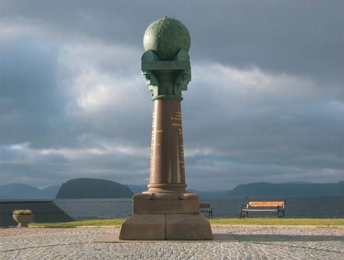
The southernmost point of the Struve Arc is the Staraya-Nekrasovka point.

Dormitory, T1607, Stara Nekrasivka, Odesa Oblast, Ukraine, 68672

The southernmost point of the Struve Arc, "Staro-Nekrasovka," is located in the Odessa region in the village of Stara Nekrasovka. This village lies on the border between Ukraine and Romania. It is situated 7 kilometers east of Izmail. The Struve Arc obelisk is located near the local Old Believers' church.

Katerynivka checkpoint, Khmelnytskyi district, Khmelnytskyi region, Ukraine

HQ84+8C Katerynivka, Khmelnytskyi Oblast, Ukraine

One of the points of the Struve Geodetic Arc is located near the village of Katerynivka in the Khmelnytskyi district of Khmelnytskyi region. The Struve Arc, once known as the "Russian-Scandinavian Meridian Arc," is one of UNESCO's World Heritage sites. The arc consists of 265 triangulation points, along which measurements were conducted from 1816 to 1852, enabling the precise determination of the Earth's size and shape.

Feldstein Point (Hvardiyske) in Khmelnytskyi Raion, Khmelnytskyi Oblast, Ukraine

8MJJ+2P Hvardiiske, Khmelnytska Oblast, Ukraine

One of the points of the Struve Geodetic Arc is located in the village of Hvardiiske (Ukrainian: Гвардійське), formerly known until 1946 as Fel'shtyn, in the Khmelnytskyi district of Khmelnytskyi Oblast, Ukraine. On June 17, 2006, a ceremonial opening of the Struve Geodetic Arc point "Feldstein" took place in Khmelnytskyi Oblast. This is a geodetic marker in the form of a triangle, which was part of a chain of such triangles stretching 2,820 kilometers. The geodetic marker itself, discovered in 2003, is located at a depth of one meter and twenty centimeters. It is a fragment of rock with a notch and markings indicating the exact coordinates—longitude and latitude. Finally, this point was arranged and a commemorative sign was placed on top.

Baranovka village, Khmelnytskyi Oblast, Yarmolyntsi Raion, Ukraine

4XXR+FJ Baranovka, Khmelnytskyi Oblast, Ukraine

The "Baranovka" point of the Struve Geodetic Arc is located in the village of Baranovka (Khmelnytskyi Oblast, Yarmolyntsi Raion).

The northernmost point - Fuglenes Hammerfest, Finnmark, Norway

Industrigata 5, 9601 Hammerfest, Norway

The Fuglenes point is located in the city of Hammerfest on the shore of the Barents Sea in a small park open to visitors. This point is a monument, next to which a granite block with a metal pin has been preserved, serving as the starting point for geodetic measurements.

Point LILLE-REIPAS Raipas Alta, Finnmark, Norway

W9Q6+F3 Alta, Norway

Point LILLE-REIPAS Raipas Alta, Finnmark, Norway. The point is marked by a modern geodetic sign and a memorial plaque. The point is located on a mountain 286 meters above sea level, in a rocky area. From here, there is a beautiful panorama of Alta (the city near which it is located), the fjord, and the surrounding mountain peaks.

Luvdiidcohkka Point Kautokeino, Finnmark, Norway

9GX5MPCF+H6

The point Luvdiidcohkka Kautokeino, Finnmark, Norway is located above the tree line; there are no trees near the point. It is now marked with a geodetic sign; previously, there was a cross under which a stone pyramid was piled. From here, there is a beautiful view of the surrounding landscapes.

Point BÄLJATZ-VAARA Baelljasvarri Kautokeino, Finnmark, Norway

27MM+88 Åvži, Norway

The BÄLJATZ-VAARA point is also located on an elevation, 90 meters above the forest line, so there are no trees near the point. It is marked by a pyramid made of stones and two metal markers installed 10 meters from it.

Point STUOR-OIVI Stuorrahanoaivi Enontekiö, Lapland Province, Finland

Ounastie 119, 99400 Enontekiö, Finland

The STUOR-OIVI Stuorrahanoaivi Enontekiö, Lapland Province, Finland point is located in the area of Mount Tarvantovaara, Enontekiö. It is one of the most inaccessible points along the entire Struve Geodetic Arc. The arc point was established in 1850-1852 and marked by a pair of crosses engraved on the rocks. The crosses from 1852 have been preserved, and the authenticity of the point is based on its continuous use and confirmed by direct measurements related to a neighboring triangulation point. To reach it, visitors will have to spend almost an entire day on foot (Enontekiö-Kautokeino or Muonio-Kilpisjärvi roads).

Point PAJTAS-VAARA Tynnyrilaki Kiruna, Norrbotten County, Sweden

7X4M+25 Paittasjärvi, Sweden

The Pajtas-vaara point is located on Mount TYNNYRILAKI at an altitude of 445 meters above sea level and is the highest point in the Pingisvaara mountainous area. The slopes of the mountain are covered with birch trees. It is situated approximately 30 km southeast of Karesuando and east of road number 99. After driving about seven kilometers on gravel roads, there is a parking lot at the northern foot of the mountain, from where you can walk one kilometer on foot. From the top of the mountain, there is a wide panorama of most parts of Finland, as well as the western flatlands of Sweden.

Point KERROJUPUKKA Jupukka Pajala, Norrbotten County, Sweden

76GV+J4 Autio, Sweden

On Mount Yupukka, there is one of the measurement points of the Struve Geodetic Arc, which is included in the UNESCO World Heritage list. In good weather, from the grassy summit, there is a view stretching for many miles wide. The Poronmaanyankka swamp with its rich flora is also part of the nature reserve.

Point AVASAKSA Aavasaksa Ylitornio, Lapland Province, Finland

Aavasaksanvaarantie 288, 95620 Ylitornio, Finland

The AVASAKSA point of the Struve Arc (currently spelled Aavasaksa, Aavasaksa) was marked by a central marker and two cross-shaped marks carved into the rock. In the 1920s, these markers were searched for by surveyors from the National Land Survey Service. At that time, they did not recognize them. During recent measurements, it was proven that the markers are located beneath the observation tower built in 1969 at the highest point of the hill. A modern triangulation point is installed on the tower, and the exact location of the arc point was determined through measurements, which confirmed that it lies directly below the position on the upper floor of the tower.

Point PERRA-VAARA Perävaara Haparanda, Norrbotten County, Sweden

2W9F+62 Karhuvaara, Sweden

The measurement station in Perevaara is the only site among Sweden's World Heritage objects where the original markings have been preserved. The point is located on the hill Alanen-Perevaara, which is completely overgrown with forest. Perevaara is situated about 25 km northwest of Haparanda, near Karungi, on a forest-covered elevation. From the small road to the measurement point, you need to walk 400 meters.

Point TORNEA Alatornion Church Tornio, Lapland Province, Finland

Kirkonmäentie 85, 95450 Tornio, Finland

The Alatornio Church is one of the few points in the Struve chain formed by buildings. The church tower served both as a measurement point and as a signal over a distance. The French expedition and Mopertuis used the church tower in the town of Tornio during their previous measurements. The tall tower of the Alatornio Church was completed only after 1797 and thus existed in its current form at the time the Struve chain measurements were conducted.

Point PUOLAKKA Oravivuori Korpilahti, Western Finland Province, Finland

Vanhanpääntie 65, 41800 Jyväskylä, Finland

The Struve Arc measurement point Oravivuori is the most famous of the points located in Finland. Oravivuori is located in Korpilahti in central Finland, which is now part of the city of Jyväskylä.

Point PORLOM II Tornikallio Lapinjärvi, Southern Finland Province, Finland

Pyhäjärventie 147, 07820 Lapinjärvi, Finland

The Porlom II point is located in the southern part of Finland, on top of the Tornikallio rock, Lapinjarvi. The point was established in 1833.

Point SVARTVIRA Mustaviiri Pyhtää, Southern Finland Province, Finland

7JG3+H7 Pyhtää, Finland

The Svartvira point is located on the island of Mustaviiri or Svartvira (Swedish name), in the Gulf of Finland, 30 km south of the city of Kotka. It is situated on flat terrain, surrounded by typical Finnish forest. The point on the ground is marked by a small, matchbox-sized hole carved into the rock.

Myakipyalyus Point, Gogland, Russia

9GG83XF9+PV

On the island of Gogland, Struve in 1826 established a unique station that connects into a single measurement two continental chains of triangles separated by the Gulf of Finland. From the Mäkypällys cliff, he observed angles and azimuths.

Point Z, Gogland Island, Russia

9GG83XP6+4C

On the island of Gogland, Struve established a unique station in 1826 that connects two continental chains of triangles, separated by the Gulf of Finland, into a single measurement. One of the island's landmarks is point "Z." This is an astronomical-geodetic point laid in 1826 upon the completion of the meridian arc measurement in the Baltic provinces of Russia.

Point WOIBIFER Võivere Outcrop, Lääne-Viru, Estonia

46233, Võivere, Võivere, 46233 Lääne-Viru County, Estonia

The Woibifer point is located in the village of Voivere in the municipality of Avanduse, on the grounds of a private yard. This point was a very important site of the Struve Geodetic Arc, as it served as the endpoint of the base elements of triangulation.

Point KATKO Simuna Avanduse, Lääne-Viru, Estonia

Rakke mnt 4, Simuna, 46401 Lääne-Viru County, Estonia

The point was established in 1827, located in a field, and marked by a stone stele 1.9 meters high, consisting of four parts. An information board is installed nearby. The KATKO point also served as a base station. To verify the locations of the base stations, their coordinates were determined using GPS, and the length of the line between the markers was calculated. The difference between the distance calculated by Struve and the measured distance was 13 mm, which proves the accuracy of his measurements.

Point DORPAT Tartu Observatory Tartu, Tartu, Estonia

Observatooriumi 9, Tõravere, 61602 Tartu County, Estonia

Punk Dorpat (Tartu Observatory) was the first point of the arc. The Tartu Observatory was built in 1810, and most of the research was conducted there. From 1818 to 1839, Struve was the director of the Tartu (then "Derpt") Observatory. Next to the observatory is the house where Struve lived while he worked at the observatory. In the park near the observatory, a monument is erected in his honor.

Monument to the former director of the Tartu Observatory, Vasily Yakovlevich Struve

Lossi 34a, 51003 Tartu, Estonia

The monument to Struve, opened in 1969, is dedicated to the former director of the Tartu Observatory Vasily Yakovlevich Struve (born Friedrich Georg Wilhelm Struve; born April 15, 1793, Altona, Germany — died November 23, 1864, Saint Petersburg) — a Russian astronomer of German origin, one of the founders of stellar astronomy. Under his leadership, between 1816 and 1855, a meridian arc was measured to determine the shape and size of the Earth (https://reveal.world/collection/duga-struve-russko-skandinavskaya-duga).

Point SESTU-KALNS Ziestu Sausneja, Region of Madona, Latvia

RJRP+4M Sidrabini, Sausnēja parish, Latvia

The geodetic point Sestukalns of the Struve Meridian is located on Ziestu Hill (216.5 m above sea level) in the Sausnēja municipality, Madona district. Latvia is the only country where Friedrich Georg Wilhelm von Struve, as well as Karl Tenner, conducted measurements and established base points.

Point JACOBSTADT, Jekabpils, Latvia

Vilhelma Strūves Street 6, Jēkabpils, LV-5201, Latvia

The Jacobstadt point was established in May-June 1826. This point is located in the historic center of the city of Jēkabpils, in the city park named after Friedrich Struve. The park covers an area of 1.2 hectares, and the adjacent street is called Struve Street in honor of the achievements of the outstanding geodesist and astronomer Friedrich Georg Wilhelm Struve.

Point KARISCHKI, Gireišiai Panemunelis, Lithuania

WC3P+2J Gireišiai, Rokiškis District Municipality, Lithuania

The point of the Struve Geodetic Arc Karischki is located near the Rokiskis-Panevezys road at the 14th kilometer on a hill in the picturesque Gireishiai valley, not far from the bend of the Setekšnari River to the west. The point is situated in an open area and was one of the base points of the Struve Geodetic Arc in Lithuania.

Point MESCHKANZI, Meškonys Nemencine, Lithuania

W8J8+CM Meškonys, Vilnius District Municipality, Lithuania

Among the three restored points of the Struve Arc in Lithuania, the "Meškonis" point is considered the most significant, as it is part of the modern Lithuanian satellite coordinate system. The point was established in 1817. Unfortunately, the geodetic points of the Struve Arc in Lithuania are neglected. Although a dirt road leads directly to the point, the UNESCO obelisk itself is overgrown with weeds, and the geodetic point is marked by a rusty sewer manhole cover.

Point BERESNÄKI, Paliepiukai Nemežis, Lithuania

JCMH+QJ Paliepiukai, Vilnius District Municipality, Lithuania

The geodetic point BERESNÄKI, Paliepiukai Nemežis is located in the village of Paliepiukai, Vilnius district, Nemežis eldership, approximately 5 km east of Nemežis. This point was established between 1816 and 1821. The point was marked with field stones that were bound together and placed in a pit. Polish surveyors re-marked the point with concrete blocks between 1925 and 1930.

Point DABOR-KALNS, Taborkalns, Selpils, Latvia

HMMR+HW Mārāni, Sēlpils Parish, Latvia

The Dabor-kanls point is located on the highest hill at the northern end of the Selia upland. Its absolute height is 157.8 meters above sea level. On Taborkalns, there is the Struve Geodetic Arc point "Dabor-kalns" and the Taborkalns observation tower, which is 28 meters tall. The point was established and used for measurements from 1825 to 1827 by the outstanding surveyor Karl Tenner, a colleague of Friedrich Georg Wilhelm Struve. The marker was rediscovered by scientists in 2015.

TUPISHKI village, Oshmyany District, Grodno Region, Belarus

72RW+P6 Tyupishki, Belarus

The TUPISHKI station is located in the Grodno region of the Republic of Belarus on agricultural land, near the village of Tyupishki, five kilometers from the town of Holshany, on an elevated wooded hill situated at an altitude of over three hundred meters above sea level. In a solemn ceremony, the geodetic point Tupishki of the Struve Arc was inaugurated.

Point LOPATY, Shchuchyn District, Grodno Region, Belarus

HV69+5W Dolgaya, Belarus

The "Lopaty" site, located in the Grodno region, near the village of Lopaty and close to the R141 Zeludok-Rozhanka highway. The object is a black stele made of gabro-diabase from Karelia, about 1.5 meters tall. At the top of the stele is a 100-kilogram sphere called "Earth," on which the outline of Belarus is visible, including the part of the Struve Geodetic Arc passing through it and the "Lopaty" symbol.

Lyaskovichi village, Ivanovsky District, Brest Region, Belarus

5H6C+7P Lyaskovichi, Belarus

The point is located 600 meters southeast of the settlement of Lyaskovichi in the Ivanovsky district of the Brest region. The center of the site is represented by a granite cube with a hole drilled into it, filled with metal. Nearby stands a memorial sign in the form of a 1.5-meter stele topped with a large sphere, as well as a hollow pyramid. The distance to Brest is 150 km. The Belarusian part of the chain was constructed by a group of soldiers under the leadership of Lieutenant General Iosif Ivanovich Khodko, a talented Belarusian surveyor, cartographer, and astronomer.

Point RUDY, Rudi, Soroca County, Moldova

8V9H+95, Rud, Moldova

In Moldova, there is a monument included in the UNESCO World Heritage List — the Struve Geodetic Arc point in Rud. The monument at this location was unveiled on June 17, 2006. During its surveys across the entire territory of Bessarabia (now Moldova), a total of 27 points were identified. Currently, only one point remains preserved in the country, located in the village of Rud. It is situated in an apple orchard, 300 meters from the Soroca–Ataki highway.

Osovnica Point, Brest Region, Belarus

7JQX+RX Osovnica, Belarus

The memorial is located in the middle of a field, which is not easy to reach. The search is complicated by the fact that the triangulation point is situated within a sown field and is very difficult to spot. The locals, as a rule, do not understand what it is about at all. Your landmark is the triangulation point on the elevation in the field, east of the village of Osovnitsa.

Chekutsk Point, Ivanovo, Brest Region, Belarus

6H54+6Q Shchekotsk, Belarus

The geodetic measurement point in Chekutsk is particularly interesting. It was excavated just a few years ago. A cube with a cross-shaped measurement mark, dated 1825, lay in the ground at a depth of about one meter. According to specialists, when conducting measurements in the Ivanovo district from one point of the Arc to the second, at a distance of about 12 km, despite temporary changes in the terrain, the difference between modern meridian measurements and the old ones was less than 3.5 cm.