Tuchkov Buyan - the legendary Biron’s palace or hemp warehouses?

Bolshoy Prospekt P.S., 1A, Saint Petersburg, Russia, 197198

Tuchkov Buyan (from the archaic *buyan* — a river pier; a place for unloading goods from ships), was mistakenly called the "Biron Palace" in the 19th century — a former building of hemp warehouses, constructed between 1763 and 1772 on the eponymous islet in the channel of the Malaya Neva, a monument of early classical St. Petersburg architecture. At the beginning of the 20th century, the channels between Buyan, neighboring unnamed islets, and Petrogradsky Island were filled in, and the name "Tuchkov Buyan" was transferred to a new urban area bounded by the modern Dobrolyubov Avenue to the north, Tuchkova Dam Street and Tuchkov Bridge to the west, Academician Likhachyov Square and Birzhevoy Bridge to the east, and the Malaya Neva to the south. The extensive block, which was planned to include Vatny Island as well, was intended to become a museum and exhibition complex; this project did not materialize due to the outbreak of World War I. In the 21st century, in the western part of Tuchkov Buyan, near the historic hemp warehouses, are located the Yubileyny sports complex and the Sportivnaya metro station.
Tuchkov Buyan (from the archaic word "buyan" — a river pier; a place for unloading goods from ships), in the 19th century was mistakenly called the "Biron Palace" — the former hemp warehouse building, constructed in 1763–1772 on the eponymous islet in the channel of the Malaya Neva, a monument of early classical St. Petersburg architecture. At the beginning of the 20th century, the channels between Buyan, the neighboring unnamed islets, and Petrogradsky Island were filled in, and the name "Tuchkov Buyan" passed to the new urban territory, bounded by the modern Dobrolyubov Avenue to the north, Tuchkova Dam Street and Tuchkov Bridge to the west, Academician Likhachyov Square and the Birzhevoy Bridge to the east, and the Malaya Neva to the south. The extensive block, which was planned to include Vatny Island as well, was intended to become a museum and exhibition complex; this project did not materialize due to the outbreak of World War I.
In the 21st century, in the western part of Tuchkov Buyan, near the historic hemp warehouses, are located the "Yubileyny" sports complex and the "Sportivnaya" metro station.

Tuchkov Bridge and Tuchkova Embankment, a mid-19th century painting. On the right, across the river, the western warehouse building and the hemp Buyan weigh house are visible.
The islet in the channel of the Malaya Neva, later named Tuchkov Buyan, emerged after the flood of 1726. Soon a pier was arranged on the islet, and in 1735 — warehouses for hemp. In the mid-18th century, the area received its name from Avraam Tuchkov — the builder of the first bridge connecting Vasilievsky Island with Petrogradsky Island. On June 29, 1761, the wooden buildings from the time of Anna Ioannovna burned down, and in 1763–1772, military engineer Dyakov built a stone Buyan building on their site based on a design by Dedenev, revised by Rinaldi. In the same years, very close to the Buyan, Dyakov built the Prince Vladimir Cathedral according to Rinaldi's design (https://reveal.world/story/knyaz-vladimirskij-sobor).
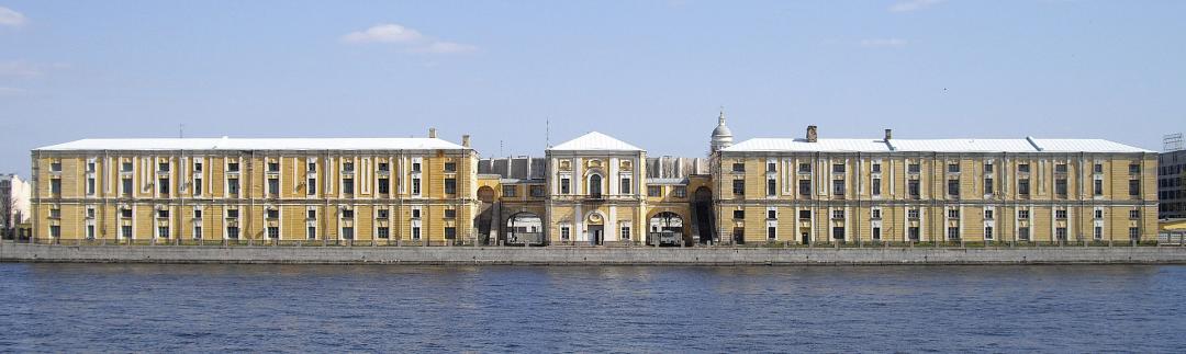
The facade of the Buyan facing Vasilievsky Island is strictly symmetrical. In the center is a compact two-story volume of the weigh house (weight office), to the left and right of it are four-story warehouse buildings connected to the weigh house by covered galleries. According to the design, the warehouses were two-storied; only during construction was each planned floor divided into two. From the north, on the side of Petrogradsky Island, the weigh house adjoined a now lost two-story, squat building of the shofa — premises for sorting flax and hemp.
The Buyan building is painted yellow. It is associated with a curious episode in 1904: artists working in the studios of the Academy on Tuchkova Embankment actively protested against painting the weathered Buyan. Kuindzhi, Klodt, and others proposed "to paint it not yellow, but gray, as it disturbs us too much with its yellow color and gives a yellow reflex in our art studios, which is inconvenient for painting…".
Until the revolutions of 1917, the Buyan was under the jurisdiction of port services (initially imperial, in the 20th century municipal) and was used as a warehouse as intended; however, both among the public and among architects and city officials, the mistaken name "Biron Palace" stuck to it. Only in 1908 did Fomin, relying on the opinions of Benois and Kotov, refute the legend in "Old Years." Fomin mistakenly dated the building to the era of Anna Ioannovna; this misconception was disproved in the 1910s.
Until the end of the 19th century, the chain of islets between Tuchkov Buyan and the Birzhevoy Bridge was not regulated; the outlines of the islets on maps of the 18th–19th centuries continuously changed, and the territory of Vatny Island was formed only by 1858. The shoreline of Petrogradsky Island had a natural, irregular shape. The swampy area to the north of it was called Mokrushi. In the 1840s, Alexandrovsky and Petrovsky parks were laid out here, and in the 1860s, Alexandrovsky Avenue (now Dobrolyubov Avenue) was laid along the shore of the channel. In the following decade, active development of Mokrushi began on the northern side of the avenue; in 1880, Alexander II approved a plan to unite the small islets with Petrogradsky Island. On the new urban territory, south of Alexandrovsky Avenue, four regular-shaped blocks were to appear.
The 1880 project was not implemented. On three islets near Tuchkov Buyan, the city placed a nursery for ornamental plants; on Vatny Island in 1896–1897, according to Marfeld's project, "red barns" of the state wine warehouse and vodka factory were built. Kurbatov, who considered the green islets on the Malaya Neva "one of the most pleasant places in Petersburg," wrote that their "view … is spoiled by the wooden Birzhevoy Bridge and the wine factory." In 1902–1905, the city expanded the dam of Tuchkov Bridge, reliably connecting Tuchkov Buyan with Petrogradsky Island; in 1908, Nicholas II approved the second official project for the expansion of Petrogradsky Island. By 1911, the channels between Tuchkov Buyan, the islets adjoining it from the east, and Petrogradsky Island were filled in; only Vatny Island remained isolated — the "fortress" of the state wine monopoly. On maps from the time of World War I, the entire new territory of Petrogradsky Island is occupied by the city nursery; active development began here only in the mid-20th century.

Ivan Fomin, 1913. Competition project for a museum and exhibition center on Tuchkov Buyan. View from Tuchkov Bridge towards the Peter and Paul Fortress. At the bottom right is the hemp Buyan building, on the left Alexandrovsky Avenue with the passage to the Vladimir Cathedral.

At the beginning of the 20th century, a new cultural center of the city was forming on the south of the Petrograd side, oriented towards the masses. Until 1897, the first St. Petersburg zoo operated on the territory of Alexandrovsky Park; in 1899–1900, the first phase of the People's House was built. In Petrovsky Park, which since 1899 was at the disposal of the Temperance Society, a theater, carousels, and a boat station were built. It is no coincidence that the new territories located between Alexandrovsky and Petrovsky parks were considered as public, popular spaces.
During preparations for the bicentennial celebration of Petersburg, proposals were repeatedly made to arrange a city museum in the "Biron Palace." In 1904, Tarasov proposed placing the city archive there. In 1905, Tarkhanov suggested creating a public-sports center; in 1906, Repin requested to allocate the Buyan building for a permanent art exhibition. Then, as the channels were filled and the territory expanded, city authorities and the public engaged in projects to arrange the "new" Tuchkov Buyan — from Tuchkov to Birzhevoy Bridge. The fate of the "old" Buyan, built by Dyakov and Rinaldi, was yet to be decided: the city seriously considered demolishing it to build a new museum and exhibition complex. Debates about demolition or preservation of the Buyan continued at least until 1915.
Active research on the new territories began around 1911–1912 in connection with plans to hold two all-Russian exhibitions in Petersburg. In 1912, the Petersburg Society of Architects, on behalf of city authorities, held the first open competition for exhibition complex projects; according to its conditions, the "Biron Palace" was to be preserved and adapted as a museum. In 1913, a second, closed competition took place between the projects of Dubinsky (winner of the 1912 competition), Munz, and Fomin. This time, architects were given the right to independently decide the fate of the Buyan, up to its complete demolition. Fomin preserved the main facade of the Buyan in his project; Dubinsky and Munz decided to get rid of it entirely. Munz wrote that the building was completely unsuitable for a museum, its reconstruction was unjustified, and its artistic value was exaggerated: "it is merely a barn, which only accidentally, or perhaps with a view to a very distant viewer, was given the appearance of a palace. The building is constructed very solidly, but crudely in details…".

With the outbreak of World War I, holding the all-Russian exhibitions became impossible, but the city continued to search for planning solutions. However, by 1915, the opinion of the architectural community shifted towards preserving historical buildings. Lidval, Belogrud, and others proposed abandoning the public center on Tuchkov Buyan altogether, moving it westward to Petrovsky Island. This approach was implemented, starting with the construction of the stadium in the 1920s.

Sources:
https://en.wikipedia.org/wiki/Tuchkov_Buyan

Follow us on social media

More stories from Petersburg: Interesting Toponyms

Is the area around Lake Dolgoe a new development or a historic district?

Park, Lake, Dolgoe, Saint Petersburg, Russia, 197371

At the beginning of the 20th century, the area near Lake Dolgoye almost became the site of a large-scale urban development project. It was planned to build a satellite city of Petersburg on the vacant lands here. In the press, the future satellite city was referred to as "American."

History of the Komendantsky Aerodrome District

Bogatyrsky Ave., 7, bldg. 5, Saint Petersburg, Russia, 197348

The name of this new development district traces its roots back to the times of Peter the Great, when the right to use this piece of land was granted by the order of Peter I to the commandants of the Peter and Paul Fortress. It began to be called the Commandant’s Dacha, and later – the Commandant’s Field. For a long time, the Commandant’s Field was located on the "outskirts" of the summer cottage areas closest to the capital. In the 19th century, it was a remote and sparsely built-up area: on the 1831 map, it is marked with gardens and fields interspersed with shrubs and groves. The only building was the Commandant’s Dacha, whose owner rented out the surrounding lands.

Konnyaya Lakhta or Kontu Lakhta — "courtyard by the bay"

Lakhtinsky Ave., 100A, Saint Petersburg, Russia, 197229

The village of Konnaya Lakhta was first mentioned in the 1573 Inspection Book of the Spassko-Gorodensky Pogost under the name "Kovduya" ("Konduya") as part of the village of Lakhta. The name "Konnaya" is a distortion of the Finnish word "kontu," which means "yard" or "farmstead." Literally translated, Kontu Lakhta means "yard by the bay." The city name Kandalaksha has a similar etymology.

Kolomyagi or Kelomyaki, another trace of Swedish presence

3rd Line Street, 2nd Half, 19, Saint Petersburg, Russia, 197375

The division of streets with the same name into "1st" and "2nd" (or "1st half" and "2nd half") in Kolomyagi is the last evidence of the hereditary division of the former village. In Kolomyagi, there were parallel lines of the 1st and 2nd halves: the 1st (now 1st and 2nd Nikitinsky Streets); the 2nd (now 1st and 2nd Alekseevsky Streets). Currently, only the third lines of the 1st and 2nd halves have retained their original names.

The History of the Name of Vasilievsky Island

Unnamed Road, Saint Petersburg, Russia, 199178

Vasilyev Island had three names at once — Russian, Finno-Ugric, and Swedish. The Russian name remained the same: Vasilyev Island (in the Swedish cadastre book — Wassilie Ostroff); the Finnish name Hirvisaari — Moose Island (in the Swedish cadastre book — Hirfwisari); the Swedish name Dammarholm, meaning Pond Island, because fish traps were located there.

The Origin of the Name. Karpovka River

nab. r. Karpovki, d. 5, korp. 16, of.201-202, Saint Petersburg, Russia, 197101

Four little huts stood by the Kuopri-Yoki river (what we call Karpovka).

Kozhevennaya Line - a new hangout spot replacing the creepy industrial zone

Kozhevennaya Line, 25, Saint Petersburg, Russia, 199106

The Kozhevennaya Line in the southwestern part of Vasilievsky Island was laid out in the 1780s. Its creation is connected with the relocation of all the leather factories of St. Petersburg to this area. These industries were characterized by unpleasant odors, which led to their displacement to the outskirts of the city. In the 18th century, the new route was called the "road to the leather factories." Its even-numbered side sometimes bordered the bay, so in the 1830s it had another name — Beregovaya Line (Coastal Line). However, the official name that stuck was the current one — Kozhevennaya Line. This place is becoming trendy and a popular hangout spot.

Old Kalinkin Bridge

Staro-Kalinkin Bridge, Staro-Petergofsky Ave., Saint Petersburg, Russia, 190121

The Staro-Kalinkin Bridge in Petersburg is one of the 7 standard stone three-span bridges over the Fontanka River, built in the 18th century and preserved to this day. In 2033, the bridge will turn 300 years old. The bridge is located in the Admiralteysky District of Saint Petersburg, with Staro-Petergofsky Avenue approaching it from the left bank. The central span is covered by a gentle circular arch, while the side spans are covered by stone vaults of box-shaped outlines.

Kirochnaya Street

Saint Petersburg, Kirochnaya 8 lit V, Saint Petersburg, Russia, 191028

Between 1775 and 1779, the Lutheran Church of Saint Anne (Annenkirche), building 8, was constructed according to the design of Y. M. Felten. The name Kirочная Street appeared in 1780 and originated precisely from this Lutheran church (the building was severely damaged in the 2002 fire). Until the mid-19th century, other names for the street were also in use: Vasilievskaya and 2nd Furshatskaya.

Furshtatskaya Street

Furshtatskaya St., 21, Saint Petersburg, Russia, 191028

The modern name Furshatskaya Street was given in 1780. It is connected to the fact that on the territory of the current house No. 21 and its inner courtyard there was the Furshatsky yard of the Life Guards Preobrazhensky Regiment.

Austrian Square

7 Mira St., Saint Petersburg, Russia, 197101

The name of the square is not historical. The square at the intersection of Kamennoostrovsky Prospekt and Mira Street (formerly Ruzheynaya) existed without a name for many years. Initially, it was intended to be called Viennese Square, but this name was too "waltzing," so in 1992 it was given the name Austrian Square.

Bestuzhevskaya Street

Zamshina St., 33a, Saint Petersburg, Russia, 195271

Many people think that the name of this street comes from the surname of the Decembrist brothers Bestuzhev. This is not entirely true; the street was named in 1912 in honor of their relative, General Field Marshal Count Alexey Petrovich Bestuzhev-Ryumin (1693–1766). At that time, shortly after the bicentennial celebration of Petersburg, several passages in Piskarevka were named after the associates of Peter I.

Osinovetsky Redoubt, Osinovaya Roshcha Fortress

Golitsynskaya St., 1x, Saint Petersburg, Russia, 194362

Osinovetsky Redoubt, Osinovaya Roshcha Fortress, 18th century — an earthen fortress (sternschanze — a fortification in the shape of a pentagonal star), a characteristic example of late 18th-century earthworks, built on the southern side of the fork in the roads to Yukki and Kexholm (Priozersk). It is located in the historic Osinovaya Roshcha district in the north of Saint Petersburg. It had stone entrance gates and ranger barracks.

Moon Cats Street

Kamennoostrovsky Avenue, Saint Petersburg, Russia, 197376

A few years ago, another cat-themed and at the same time the most mysterious and romantic spot appeared on the "people's map" of the city – Moon Cats Street, the popular name for the passage between house No. 77 on Kamennoostrovsky Prospect and house No. 3 on the embankment of the Malaya Nevka.

Avtovo (historical district)

Zaitseva St., 6-1, Saint Petersburg, Russia, 198096

Even before the time of Peter the Great, there were several villages in this area — Laurola, Niprola, Lakhta by the Sea, Vallakyulya, and others. On pre-Petrine maps, at the site of present-day Avtovo, the village of Autova (Аутова) is visible (a plan from 1699), or Autovo (Аутово) (on Bergengheim’s map, compiled by him in the 19th century based on archival data from 1676). Referring to these data, many researchers derive the modern name of the area from the Finnish word “autio,” which means “deserted,” “abandoned.” There is also a theory that Avtovo comes from one of the Finnish terms for bear (Ovto) or from the name of a net (Otava).

Okhta (historical district)

Helipad, Saint Petersburg, Russia, 195027

There is a popular legend that during a visit to a shipbuilding yard on the right bank of the Neva, Peter I, walking along one of the streets of Matrosskaya Sloboda, suddenly sank almost waist-deep into the mud. Returning to Petersburg and telling about it among his close circle, he half-jokingly, half-seriously exclaimed: "Oh, I'm tired of that side!" The phrase caught on, and part of it turned into the very name of an entire district.

Are the streets called Zeleinye or Zelenina? (Bolshaya Zelenina, Malaya Zelenina, and Glukhaya Zelenina)

Lodeynopolsky Square, Bolshaya Zelenina St., 23, Saint Petersburg, Russia, 197110

Bolshaya Zelenina Street runs from Maly Prospekt of the Petrograd Side to Admirala Lazareva Embankment. It is one of the oldest streets on the Petrograd Side. Originally, a road passed here from the Peter and Paul Fortress to the gunpowder factory, which was relocated here from Moscow at the beginning of the 18th century. Both the factory and the road were called "zeleinye" (in old times, gunpowder was called "zelye"). The name of the main street, Zeleinaya, gradually changed to Zelenina. The gunpowder factory on the Petrograd Side existed until 1801. The names of the nearby Malaya Zelenina and Glukhaya Zelenina streets are connected with the name of Bolshaya Zelenina Street.

Bolshaya and Malaya Monetnye Streets

Bolshaya Monetnaya St., 16b, Saint Petersburg, Russia, 197101

Since the 18th century, there has been a settlement of "working people" of the Mint here.

History of the Moyka River

Moika River Embankment, 89, Saint Petersburg, Russia, 190000

Moyka (historical name until 1797: Mya) is a right branch of the Fontanka River flowing into the Bolshaya Neva. It flows out from the Fontanka along the southern border of the Summer Garden and the Field of Mars.

History of the Fontanka River

Fontanka River Embankment, 115, Saint Petersburg, Russia, 190068

The small swampy river Golodusha, later called Nameless Yerik, then the Fountain River. The idea is connected with the fountains of the nearby Summer Garden — that is why the river is called Fontanka. In 1737, it received its current name, and by 1952, a wooden embankment had appeared. Later, the river was cleared and deepened again, and the embankments became granite.

Chapaev Street

Chapaeva St., 17k2, Saint Petersburg, Russia, 197046

There is a Chapaev Street in Saint Petersburg. It is located in the Petrogradsky District and stretches from Kuibyshev Street to the embankment of the Karpovka River. It received its name in 1952 by the decision of the Leningrad City Executive Committee. Note that in Leningrad, at the beginning of Tikhoretsky Avenue, a monument to Vasily Chapaev was erected. Paradoxically, but true. Vasily Ivanovich Chapaev was never in the city of Petersburg. But it was in Leningrad that he became a cinematic hero.

Malaya Posadskaya Street (Bratyev Vasilyevykh)

Malaya Posadskaya St., 22-24, Saint Petersburg, Russia, 197046

Brothers Vasilyev Street appeared in the city on the Neva at the end of autumn 1964. It was an old street that previously bore the name Malaya Posadskaya (Petrograd Side). The street has now been restored to its historical name.

The Legendary Vvedensky Canal: History of Its Origin and Loss (Vvedensky Canal Street)

Vvedensky Canal, 10, Saint Petersburg, Russia, 190013

The history of the Vvedensky Canal in Saint Petersburg, which appeared and disappeared, is quite interesting; it has long become an urban legend of Petersburg.

Income Houses of the Joint-Stock Company "New Petersburg"

Zheleznovodskaya St., 19, Saint Petersburg, Russia, 199155

Income house of the joint-stock company "New Petersburg," part of the project for the development of the territory in the western part of Goloday Island (Decembrists' Island). Designed in 1911-13 by architect I. A. Fomin with the participation of architect F. I. Lidval. The project for the large residential area is based on the characteristic radial-ring system typical for St. Petersburg.