
The paved roads of the Maya were called sacbe (Spanish: Sacbé, plural — sacbeob (Spanish: Sacbéob)) and were substantial roads made of gravel, pebbles, and limestone, connecting the most important parts of the Maya state — cities, temples, large agricultural areas, and so on. These substantial elevated roads were usually built in lowlands that flooded during the rainy season. Where this was not necessary, roads were constructed with slight elevation or level with the ground. In mountainous areas, trails were laid out.
All sacbe had ritual or religious significance. The writer-traveler and early Mayanist John Lloyd Stephens reported that some local Maya residents on the Yucatán still recited a short ritual prayer when crossing a sacbe in the early 1840s, even though by that time these roads had been overgrown by jungle for centuries.
Undoubtedly, sacbe also had practical importance in addition to any religious significance. They were certainly used for trade and communication. The Maya had no pack animals suitable for transporting goods over long distances, so it is quite likely that merchants regularly traveled along sacbe, although it is also known that the Maya used water routes. Along large sacbe, there are many mounds often interpreted as remains of huts or waystations for travelers. Looking at the large sacbe connecting Kabah with Uxmal, locals told John Lloyd Stephens that ancient Maya couriers used sacbe to deliver messages between major cities. In Aké on the Yucatán, several sacbe lead directly to cenotes, which served both as important religious sites and sources of fresh water.

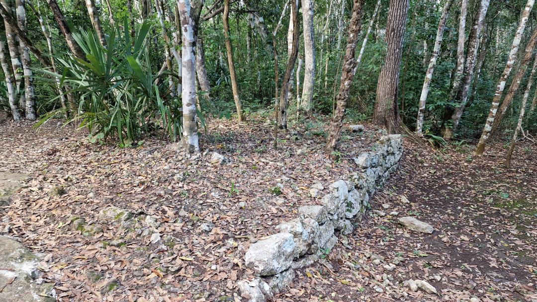
A sacbe was an embanked paved road made from various types of stone. Limestone, pebbles, and gravel were used in construction. The entire surface was covered with a thick layer of coarse plaster. Unlike Inca roads, which had a fixed width of 7.3 meters, the width of Maya sacbe varied from five to twenty meters. The height of the road embankment ranged from 0.6 to 2.5 meters depending on the elevation above sea level (in lowlands, a large embankment was needed to prevent flooding during the rainy season). It is unknown what units the Maya used to measure the length of their roads. Remnants of the transportation system have survived to the present day. Many routes crossed all Maya lands and reached the coast. The Spaniards were amazed that sacbe were laid even through impenetrable jungles and that one could walk along them without fear of getting lost. A paved trail from Campeche to Lake Bacalar — the center of Maya shipbuilding, where canoes were built, the basis of the Maya fleet — was known. The existence of sacbe roads is confirmed by aerial photography, Hernán Cortés’ records, and the testimonies of many Spanish travelers.
In Cobá, there are more than 50 sacbe, which are still visible today. Some researchers believe that some of them were used to divide a population of about 55,000 people into at least four barrios or districts. Many smaller sacbe lead to water sources or other places with intense traffic, such as ceremonial or administrative centers. Two much larger sacbe connect Cobá with smaller settlements Yaxuná, nearly 100 km to the west, and Ixil, about 20 km to the southwest. Since Cobá is the only major Classic period site in an area of 5,000 square kilometers around it, Yaxuná and Ixil are believed to be outposts or satellite settlements of Cobá, which was the capital of the state in which they all lived.
The Cobá-Yaxuná sacbe is the longest known ancient stone road in the Maya world. It stretches approximately 100 km across the Yucatán Peninsula along an east-west axis between the two sites and is believed to date from the period between the end of the Late Classic (600–900 AD) and the beginning of the Terminal Classic (900–1100 AD). The plans for building sacbe, bridges, and other road structures were made by an engineer who also supervised the construction process. Initially, workers laid a base of roughly processed limestone mixed with gravel and pebbles along the entire path. Stones could weigh from 11 to 136 kg. On top, wet limestone gravel was compacted. In the final stage, the road was covered with coarse plaster. A roller was also used during construction. A five-ton stone roller was found near the city of Ekal. The surrounding Maya settlements were obligated to participate in the construction and repair of the road system. The labor of the settlers was not easy — vegetation often overtook entire kilometers of paths and had to be cleared, the sacbe masonry would crumble and needed restoration. In areas with dense vegetation, trees could even grow through the roads. Bridges over rivers deteriorated over time and had to be repaired or sometimes rebuilt. As for the construction of new roads, usually an engineer or a whole team came to carry out the design task by order of the local chief, and in the case of especially large sacbe — by decree of the king. The population near the construction site was obliged to participate in the work.
Construction proceeded quite quickly — calculations show that each worker could carry up to 680 kg of materials per day. In a month, tens of kilometers of road could be laid. For example, in 1564 the Spaniards decided to build the Mérida-Maní road, and 80 km were covered in three months by three hundred indigenous workers.
This sacbe is by no means a winding path through the forest. The roadway, when on flat ground, is raised 40–45 centimeters high at various points and is about 10 meters wide. This width is roughly the same as a typical modern two-lane road. When the sacbe crosses wide, deep ditches and other very uneven terrain, the roadway is raised, sometimes up to 2.5 meters high. The road has long straight sections with rare adjustments in slope angle. These dimensions are not unique to this particular sacbe and correspond to the general plan of other sacbe throughout the Yucatán. However, it should be noted that recent LiDAR images show that the sacbe is not as straight as originally thought.
To get an idea of the enormous amount of labor required to build this road through the heart of the Yucatán forests, calculations show a huge volume of work: the project would have required 1,000 workers working 12 hours a day, 7 days a week, for nearly two years. This would have included clearing the forest; leveling the surface; quarrying limestone slabs from numerous nearby quarries to create side walls 45 centimeters high; transporting slabs to the roadway; and then filling the approximately 10-meter-wide space between them. It would also have included gathering and preparing food and water to supply this labor force in the remote forest.
Researchers have identified small fragments on the road surface covered with smooth plaster. The surface of the studied sections of the Cobá-Yaxuná sacbe, although flat, is heavily fragmented due to centuries of forest cover. No one has analyzed the composition of the road surface or whether it was fully plastered. However, if this were also the case with the Cobá-Yaxuná sacbe, it would have required additional and significant labor and resources for production and application. The figures given also do not reflect the labor needed for year-round maintenance of the road in tropical conditions.
There is a report by Alfonso Villa, who explored the entire length of the sacbe back in 1934. It took him 22 days with 12 workers armed with machetes to cut their way through. He includes the finding of Eric Thompson, who determined that the top of the sacbe is a mixture of soft limestone conglomerate and plaster. The underlying layer was apparently compressed by a large stone roller, which Villa found on top of the sacbe. Villa also reports traces of lime plaster on the side walls. He also reported a number of small stelae containing glyphs embedded in the sacbe, which unfortunately have been erased. A recently published report by the famous epigrapher David Stuart deciphered a glyph marker that reads “SAK-BIH-hi,” the Cholan form of the Yucatec word sakbeh.
There is also evidence of the existence of road stations and inns among the Maya, as many sacbe had cross-shaped mounds at regular intervals. A similar system is well known among the Incas, but the Maya system is practically unexplored. However, it is known that the city leader was required to maintain an inn for travelers and ensure that there was always enough water, firewood, corn, food, and some other supplies. Every 8 kilometers, the Maya placed a special marker post to indicate distance. It can be inferred that 8 km in our system was a unit of measurement for long distances among the Maya. Moreover, according to the testimony of the Spaniard Diego de Landa, these posts had a sacred meaning — travelers lit copal incense in honor of Ek Chuah, the Great Shaman and God of the North Star, patron of travelers and merchants.
What was the purpose of this extraordinary expenditure of resources and labor? The previously mentioned 1934 report mentions a number of small sections that could explain the angular deviations of the sacbe, but these would certainly be secondary to the main purpose. It has also been suggested that the sacbe was a pilgrimage route. But why an embanked road rather than just a path cut through the forest? Cobá was a large Classic Maya settlement that controlled a vast region on the eastern coast of the Yucatán. It reached its peak in the Late Classic (600–900 AD). Sacbe have been found leading out of Cobá in several directions. A 22-kilometer sacbe connects to a small site and the cenote Ixhil to the southwest. Another, possibly more important sacbe leads southeast toward the important coastal trading center of Xel Há, located 45 km from the site. Other roads go north, but all are much shorter than the Cobá-Yaxuná sacbe and, in any case, apparently have not been studied in detail. So what was so important about Yaxuná? It is a medium-sized city without any obvious natural resources. However, there are military reasons. Researchers have suggested that Yaxuná was a remote military outpost of Cobá. This allowed them to keep in check the important rival city of Chichén Itzá, which is only 20 km away and, as one might assume, was within their sphere of influence. Indeed, ceramic and other archaeological evidence shows that at the end of the Classic period, forces from Chichén Itzá occupied this place and destroyed a number of its structures. It has also been suggested that this place was an important trade crossroads where goods from across the peninsula and beyond were exchanged. But again, why a raised road? However, this place may also have been a spiritual center of great importance to the rulers of Cobá. In Cobá, the sacbe begins at the main pyramid complex of Nohoch Mul, which has the tallest pyramid in the Yucatán, and ends at the steps of the temple in the ceremonial complex of Yaxuná. Research conducted in the 1990s showed that Yaxuná was an important Preclassic site (300 BCE – 200 CE), the largest in central Yucatán at that time.
There are many sacbe in the Maya realm. Some are relatively short within a specific site, connecting individual structural groups, while others connect separate cities. Their place in Maya culture is not fully understood. For example, the Inca road system in South America was extensive and covered thousands of miles. The system included waystations and supply depots. Only members of the royal family, warriors, and those with official permission were allowed to use these roads. There were tolls for passage and use. There is also evidence of road stations and inns among the Maya, as many sacbe had cross-shaped mounds at regular intervals. Such a system is well known among the Incas, but the Maya system is practically unexplored. However, it is known that the city leader was required to maintain an inn for travelers and ensure that there was always enough water, firewood, corn, food, and some other supplies. Every 8 kilometers, the Maya placed a special marker post to indicate distance. It can be inferred that 8 km in our system was a unit of measurement for long distances among the Maya. Moreover, according to the testimony of the Spaniard Diego de Landa, these posts had a sacred meaning — travelers lit copal incense in honor of Ek Chuah, the Great Shaman and God of the North Star, patron of travelers and merchants.
Some sacbe studied in the northwest Yucatán appear to have been built during times of conflict, rapid population growth, and migration, and some have interpreted them as "permanent lines of communication, evidence of close relationships between dominant centers and satellite settlements," effectively a way of marking and maintaining political boundaries. The modern Maya term for the Milky Way is also called Sacbe. The fulfillment of someone's destiny is considered the completion of their "path." Given that movement, roads, and space are important in Maya myths, the association of Sacbe with the Milky Way suggests a ceremonial significance of Sacbe.
Sources:
https://en.wikipedia.org/wiki/Coba