Caspian Fort Boyard - Workshop 8 of the Dagdiesel Plant

VP85+RM Turali 4th, Republic of Dagestan, Russia

The most incredible building of the Soviet avant-garde is located in the Caspian Sea, 2.7 kilometers from the shore. This artificial island has become a kind of calling card for the Russian part of the Caspian Sea. Initially shrouded in secrecy, it now patiently awaits the decision of its fate.

The most incredible building of the Soviet avant-garde is located in the Caspian Sea, 2.7 kilometers from the shore.

A bit of background. Torpedoes are expensive weapons. After assembly at the factory, a torpedo requires testing, called zeroing. On the finished torpedo, rudders responsible for depth and course are set at specific angles. Then it is fired from a torpedo tube. It must travel a set distance at a certain speed, at a specified depth, along the required course. Afterwards, special boats called torpedo catchers retrieve it. Torpedoes that pass the zeroing tests are handed over to the customer – the Navy. The Navy has special ships where all new types of naval weapons undergo initial testing. Some of these ships are equipped for torpedo testing. However, once torpedoes are produced in mass quantities, a special shore-based zeroing station becomes necessary.

In the 1930s, the Soviet Union did not have a stationary zeroing station. Considering the increasing production of torpedoes, it was simply essential. A meeting was even held with Stalin on this issue. Options for placing the station in the Caspian Sea were considered – near Baku or in Kaspiysk. The People's Commissar of Heavy Industry, Sergo Ordzhonikidze, proposed to build such a station in Kaspiysk. On one hand, Baku was close to the state border with Turkey and Iran. On the other hand, Kaspiysk – then the settlement Dvigatelstroy – was located in the ice-free part of the Caspian Sea, which was very important. The depths and hydrology were ideal for creating a torpedo zeroing station.

In the 1930s, near Kaspiysk, construction began on secret machine-building plant No. 182, which was to produce underwater weapons and diesel engines for ships and equipment. There were no suitable islands in the area, so it was decided to place the gigantic zeroing (testing) workshop directly in the sea for the first time in domestic history.

The project was led by engineer Alexander Dezortsev, who was educated in Europe and by that time had built the largest hydraulic structures, dams, and power plants in the USSR.

The technical solution of the building was unprecedented. On the shore, in an excavated pit on a wooden pavement within formwork, the massive workshop foundation, a "pontoon," a huge reinforced concrete "box" 14 meters high, was poured. Simultaneously with concreting the foundation, a 6-meter-high "cushion" of stones was piled up at the future island site 2.7 kilometers from the shore using special barges. Then the artificial dam separating the pit from the sea was destroyed, and the floating "box" was towed to the station construction site in February 1935. There, the "box" was filled with water and "set" on a pre-prepared platform of rubble stone. Construction of the station then proceeded in the usual way, with people and materials delivered by sea vessels. A construction report dated October 10, 1936, noted: "The giant reinforced concrete mass on the sea, on the prepared foundation, on which the main building will be constructed, has been installed. Construction work and equipment installation will be completed in 1937."

The construction faced incredible difficulties and delays – starting with the fact that only 35 people with two horses and a tractor began digging the huge pit, and ending with the impossibility of working blindly in murky water.

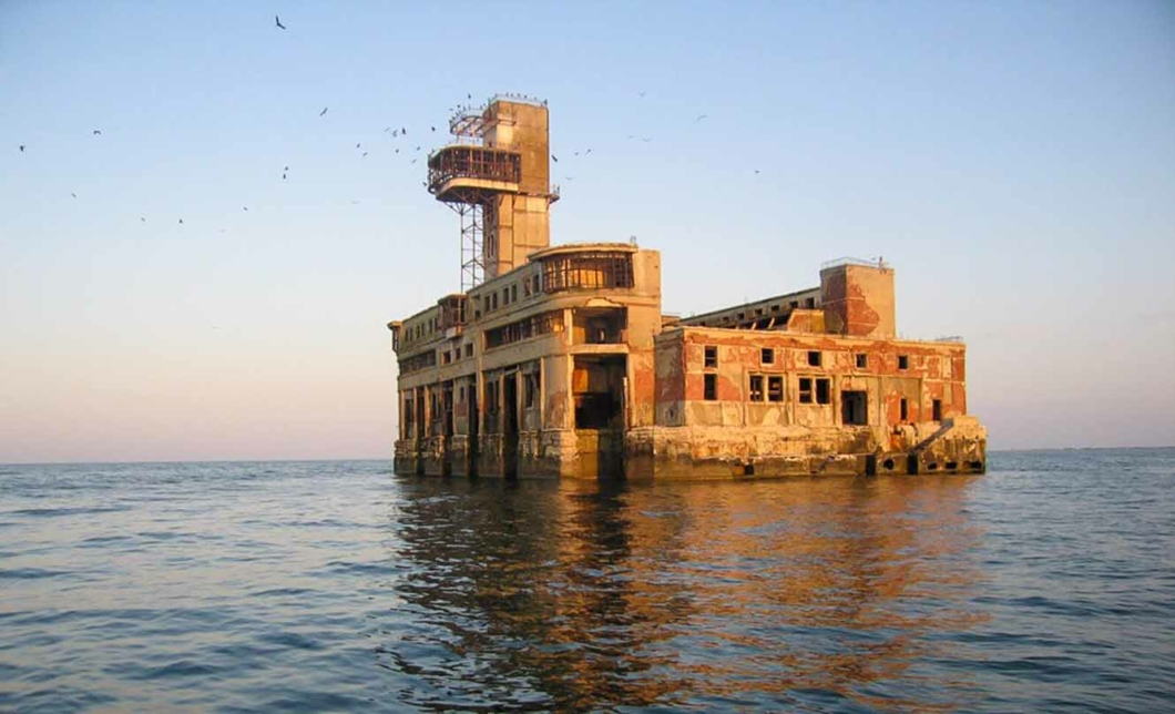
In January 1937, the under-construction workshop "A" was renamed workshop No. 8. The layout drawings of the above-water part of the eighth workshop were developed by chief engineer A. Dezortsev, project manager Akhtenshtein, senior engineer Matevosyan, and designer Parfenov. This workshop was commissioned in 1939. The inventory card listed: a building with an area of 5,189 sq. m, total volume of 26,000 cubic meters, installed on a reinforced concrete foundation, brick walls, reinforced concrete ceilings, parquet floors. Ultimately, the artificial island took on the appearance of a fantastic castle with a tower. Considering the harsh nature of the Caspian winter, the glass thickness was seven millimeters. In official secret documents, it was called the "pavilion" object.

There was an elevator that lifted to the observation tower located on the ninth floor. Since the Caspian weather was often rough and testers could be delayed for a long time due to storms, the right wing of the workshop on the upper floors housed a canteen, a hotel, and even a library. In the middle of the basement, in a large sports hall, workers played basketball and volleyball. To provide communication with workshop No. 8 and its servicing, northern and southern piers of the port, a pier, and a ship repair workshop were built on the shore.

The authors of the above-water part paid special attention to the architecture of the project. The striking silhouette of the workshop with a tall tower and a powerful observation platform overhang became a symbol of the city and was placed on the coat of arms of Kaspiysk. The carefully designed facades with rounded projections, "captain's bridges," and vertical ribbon windows suggest that the authors were well acquainted with European Art Deco and the new Soviet style – Constructivism. Until 1966, tests were conducted from time to time – old-type torpedoes were still being produced. In 1966, the workshop was closed but remained guarded. The zeroing station was moved to the settlement of Ordzhonikidze in Crimea. Workshop No. 8 was abandoned. Ten years later, in 1976, the guard was withdrawn. Upon withdrawal, all documentation was destroyed. Between 1978 and 1995, the Caspian Sea level rose, and waves began to destroy the reinforced concrete foundation of the artificial island. Kaspiysk housed the testing base of TsKB-19 – today the Central Design Bureau for Hydrofoil Ships named after Alekseev. They conducted tests of combat ekranoplans. Since the workshop formally remained on the balance sheet of "Dagdizel," testers used it to practice firing guns from ekranoplans. The tower was hit on one side and slightly tilted. Additionally, shells hit the torpedo ports – the gates from which torpedoes were fired. First, a fire broke out inside the workshop from the shots, then the incoming water began actively destroying the interior of the workshop.

At the end of the USSR era, a private individual offered to buy the workshop and organize a restaurant, hotel, and casino with its own pier. The plant, which owns the artificial island, agreed. But the still powerful KGB of the USSR was categorically against it.

The workshop No. 8 attracted the interest of maritime border guards – they needed an external observation post. But an insurmountable contradiction arose in this matter. Divers inspected the island's foundation. Their conclusion – the foundation is fully suitable for further operation. An expert commission that examined the buildings on the island concluded that their use was impossible. The border guards refused workshop No. 8.

Workshop No. 8 is a symbol of Kaspiysk, a symbol of "Dagdizel," and in a certain sense – a symbol of the Russian part of the Caspian Sea. Some call it the most mysterious object of the Caspian.

Sources:

https://welcomedagestan.ru/placepost/8-j-tseh-zavoda-dagdizel/

https://www.bankgorodov.ru/sight/ceh--8-zavoda-dagdizel

https://versia.ru/na-ostrove-poxozhem-na-srednevekovyj-zamok-ispytyvali-novye-torpedy

https://etokavkaz.ru/istoriya/kaspiiskii-fort-boyard-taina-kotoroi-ne-bylo

Follow us on social media

More stories from Dagestan: History, Mysteries, and Legends

Ekranoplan "Lun" - Caspian Monster

W9RH+8F Arablar, Republic of Dagestan, Russia

One of the projects of new and promising weaponry created in the 1980s was the ekranoplan "Lun." Abroad, these aircraft were admired for their interesting appearance and feared for their capabilities. Due to changes in the country, there was an attempt to convert the ekranoplan "Lun" from a ship destroyer into a rescue vehicle, but later it was completely abandoned and left to fate at one of the factories.

Caucasian War, Gimrinskaya Tower - the leap of Imam Shamil

PVWF+XP Gimry, Republic of Dagestan, Russia

Not far from the village of Gimry stands a stern defensive tower known as the Gimry Tower. It was built for the defense of the aul by Ghazi Muhammad and his murids, among whom was Shamil, after the defeat at Khunzakh in 1830. The Gimry Tower is believed to be a witness to the death of Ghazi Muhammad – the first Imam of Dagestan.

Caucasian War, Storming of Akhulgo

FC7V+H9 Takunzakkuli, Republic of Dagestan, Russia

The mountaineers, despite the inevitable death, refused to surrender at all costs and defended themselves with frenzy: women and children, with stones or daggers in their hands, threw themselves onto bayonets or, in despair, threw themselves into the abyss to certain death. It is difficult to depict all the scenes of this terrible fanatical battle: mothers killed their own children with their own hands, just so they would not fall into Russian hands; entire families perished under the ruins of their huts. Some of the murids, exhausted from wounds, still wanted to sell their lives dearly: even while surrendering their weapons, they treacherously dealt death to those who tried to take them.

Caucasian War, Assault on Akhulgo - Surkhaev Tower

QPCW+Q2 Ashilta, Republic of Dagestan, Russia

Having studied the area, General Grabbe decided that, first and foremost, it was necessary to capture the Surkha Tower. On June 12, siege operations began. Batteries were set up in five locations. Due to the lack of soil, the gun platforms were filled with stones. Moreover, transporting the cannons to various locations was an incredible challenge. In some places, the road had to be carved directly into the rocks.

Gunibsky (Tsarsky) Tunnel

CW7G+86 Gunib, Republic of Dagestan, Russia

Gunib Tunnel, or the Tsar's Tunnel, as it is called by the locals. Year of construction: 1866-1867. Length: 103 meters, height: 6 meters, width: 4 meters. The tunnel was built (carved out by hand) for strategic and communication purposes by Russian soldiers and local residents.

Sarykum Dune - nature, Dumas, White Sun of the Desert, and more

265J+43 Khumtop, Republic of Dagestan, Russia

The first mention of the Sarykum dune is found in the book by the famous French novelist Dumas, published in Paris in 1861, titled "The Caucasus from Prometheus to Shamil."

Kum-Torkale Station

263Q+73 Burlavai, Republic of Dagestan, Russia

The remains of the abandoned Kum-Torkale railway station are located at the foot of the Sarykum sand dune in the Kumtorkalinsky district of Dagestan. It once belonged to the now-vanished village of Kum-Torkale. The village was completely destroyed in 1970 by a strong earthquake.

Pushkin-Tau (Izbergtau)

R. Zorge, 40a/1, Building 1, Entrance 1, 4th floor Izberbash, Republic of Dagestan, Russia, 368500

Pushkin-Tau (Izbergtau) is a mountain located in the vicinity of the city of Izberbash. It stands at an altitude of 220 meters above sea level. Pushkin-Tau is a combination of many rocks that overlap each other, and only from one specific spot can the profile of the great poet A. S. Pushkin be clearly seen.

Cavalier Battery Rock or Tamerlane Rock

32 Zulpukarova St., Buynaksk, Republic of Dagestan, Russia, 368220

The Cavalier-Battery Rock, formerly known as Tamerlane Rock, is one of the landmarks of Buynaksk (Temir-Khan-Shura). The conqueror's tent stood on it, and Tamerlane could see the entire surrounding area, while his guards could see all threats. From here, he sent punitive expeditions to the mountains of Dagestan.

Saltinsky Underground Waterfall

93Q8+QR Silta, Republic of Dagestan, Russia

The Saltinsky Underground Waterfall is the highlight of Dagestan, a true wonder of nature hidden from prying eyes deep within the planet's interior. Located in the canyon of the Saltinka River, it is recognized as a natural monument of regional significance.

Shamil's Gazebo or Baryatinsky's Rotunda

9WWP+8X Gunib, Republic of Dagestan, Russia

Monument to the people's feat in the Caucasian War, the place where the final point was set in the Caucasian War in 1859. At this site, negotiations took place between Imam Shamil and Prince Baryatinsky.

The Gimry Road Tunnel is the longest road tunnel.

Gimrinsky Road Tunnel, Republic of Dagestan, Russia

The Gimrinsky Road Tunnel is the longest road tunnel in Russia. Located in Dagestan, it connects Buynaksk and the village of Gimry, providing the shortest and weather-independent transportation link for the construction of the Irganayskaya Hydroelectric Power Station, as well as for nine districts of mountainous Dagestan to the railway and the republic's center. The length is 4,303 meters.

A wooden bridge without a single nail

WRVM+JC Shile, Republic of Dagestan, Russia

In the Dagestani village of Gulli, there is a mysterious wooden bridge that bears the weight of centuries. Less than a hundred kilometers from the tourist city of Derbent, on the road leading to the Khanag Waterfall, lies the equally charming village of Gulli, where people come to see the wooden bridge that carries the burden of centuries. It is thrown over a small and shallow tributary of the Khanag-Chay River. The bridge is reliably constructed: once oxen with carts passed over it, and today it can support a passenger car.

The Fortress of Seven Brothers and One Sister or Khuchnin Fortress

village, Khuchni, Republic of Dagestan, Russia, 368650

The fortress of seven brothers and one sister, also known as Khuchninskaya, Yagdygskaya fortress, is part of the defensive system (the Caucasian Wall) that protected the local inhabitants of Dagestan from nomadic invasions. It was built in the 7th–8th centuries. It is a continuation of the Derbent fortress, whose construction took place from the 6th to the 16th centuries.

Kubachi - a famous village of jewelers and gunsmiths

3JM3+PM Kubachi, Republic of Dagestan, Russia

One of the largest traditional centers of metalworking in the Caucasus, as well as stone and wood carving. Known since the early Middle Ages for the production of chainmail and weapons.

Akhtyn Fortress

FP9Q+CW, Akhty, Republic of Dagestan, Russia, 368730

Akhtynskaya Fortress (Lezgian Akhtsegh-Kyele) is a Russian fortress in Dagestan, located in the village of Akhty in the Akhtynsky District, built in 1839 by General Golovin. It is a historical and architectural monument of federal significance. The southernmost fortress on the territory of Russia.