The Fuglenes point is located in the city of Hammerfest on the shore of the Barents Sea in a small park open to visitors. This point is a monument, next to which a granite block with a metal pin has been preserved, which served as the starting point for geodetic measurements.
Nearby the monument (20 m away) is the local school; the monument site is visible from a great distance. It is visited by more than 5,000 people annually.
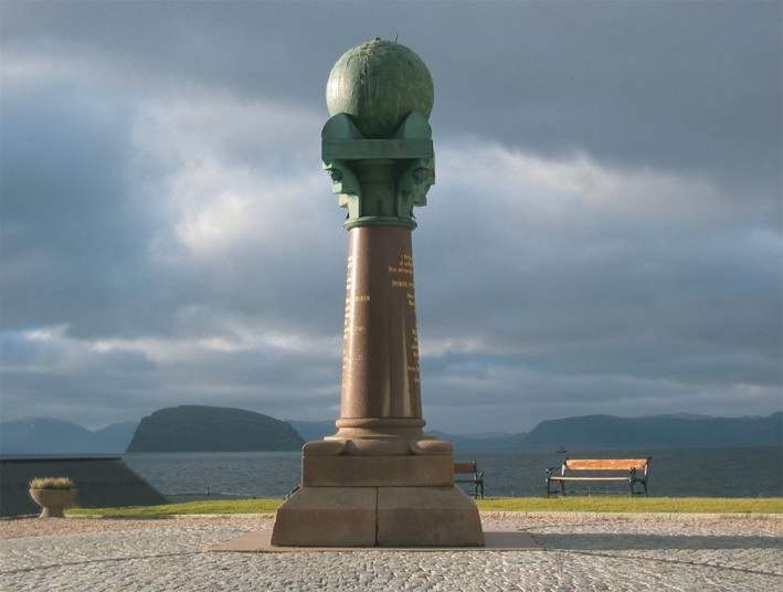
The monument was designed by architect Wilhelm von Hanno and erected in 1854 to commemorate the completion of the largest international project to measure the shape and size of the Earth. The pedestal with the base, column, capital, and globe is an example of the styles that inspired von Hanno. The foundation consists of three parts and is made of unpolished granite. While the two lower parts are almost square, the upper part is shaped like a leaf, where the tip of the leaf forms corners pointing north, west, south, and east. On the round base stands a column made of polished granite. The column is conical, becoming narrower in diameter as it rises.
The monument at Fuglenes is listed by UNESCO and is a protected cultural heritage site. The support bears the following inscription: "The northernmost endpoint of the 25°20' meridian arc from the Arctic Ocean to the Danube River — through Norway, Sweden, and Russia. By agreement of His Majesty Oscar I, Emperors Alexander I and Nicholas I, with the help of continuous geometric measurements. Latitude 70° 40' 11.3''."
The Struve Geodetic Arc, once known as the "Russian" and later the "Russo-Scandinavian meridian arc," is one of UNESCO’s World Heritage monuments. The arc consists of 265 triangulation points, along which measurements were conducted from 1816 to 1852, enabling the precise determination of the Earth's size and shape.
The reference points of this triangulation network were marked on the ground in various ways: hollows carved into rocks, iron crosses, stone pyramids, or specially erected obelisks. Often they were marked with sandstone bricks laid at the bottom of a pit; sometimes it was a granite cube with a cavity filled with lead, placed in a pit with cobblestones.
During the 8-year project to include the Struve Arc in the UNESCO list, special search and geodetic work was carried out in each country to locate the original points. All information from all the Struve Arc countries was collected, structured, and standardized.
Not all of the original points were found during the special search and geodetic work undertaken in recent years with active cooperation from scientists of the interested countries, and many of them were found to be heavily damaged. Therefore, only the best-preserved points — a total of 34 — were included in the World Heritage site.
Sources:
https://en.wikipedia.org/wiki/Fuglenes