Quintana Roo Nuevo Durango - Coba 175, 77793 Q.R., Mexico
Koba is located in the western part of the Mexican state of Quintana Roo, near the border with Yucatan. The city clusters its architectural ensembles around five lakes, two of which (Koba and Makanshok) are in its central part, while the other three (Shkanha, Sakalpuk, and Yashlaguna) border it from the outside. The first mention of Koba belongs to Stephens and dates back to 1842; however, the well-known traveler was unable to visit the ruins of the ancient city. Between 1926 and 1932, the Washington Carnegie Institute under Thompson’s leadership conducted a series of studies on the monument. However, a full-scale investigation of the ancient city began in 1974 with the work of the National Institute of Anthropology and History of Mexico and continued until the early 1980s, which saved the city from early unprofessional excavations and the removal of finds to the USA.
Traces of the earliest activity recorded on the territory of Koba date to the beginning of the Early Classic period, the first to fourth centuries AD. The monumental center was formed in the Early Classic period, the fifth to sixth centuries, during which the Koba complex was built, as well as secondary complexes such as San Pedro in the north, Kitamna in the southwest, and Nuk-Mul to the south of Koba. In the Late and Terminal Classic periods, in the seventh to ninth centuries, Koba turned into a huge densely populated city comparable in area and population to Tikal. New architectural complexes arose within the monumental center, such as Nohch-Mul, Chumuk-Mul, Makanshok; a branched network of roads was created, having regional (sacbe in Yashunu and Ishil, 100 and 19 km long respectively), zonal (sacbe connecting the center with secondary suburban complexes), and local significance. In the seventh to eighth centuries, there was a surge in monumental activity — between 613 and 780 AD, at least most of the hieroglyphic stelae were erected, totaling 34 relief and 10 smooth ones, as well as several hieroglyphic panels.
In the Postclassic period, unlike most Classic Maya cities, Koba retained its power — apparently, strict control was established over the trade route along the modern coast of Quintana Roo, with the port center of Shelha possibly serving as its outpost. Construction activity continued within the urban epicenter — the Chumuk-Mul group, formed in the Late Classic, expanded, and a new complex known as the “Painted Group” was built, executed in the typical Costa-Oriental style of this period and region (a vivid example of this style is, for instance, the architecture of Tulum).
The total area of the city and its surrounding district is at least 64 square kilometers. Based on the density and type of development, Koba is conventionally divided into four zones: the monumental center and its outskirts, the peripheral zone including secondary architectural complexes, and an additional zone where residential areas are located. The first, second, and a smaller part of the fourth zones form the city of Koba itself (19 square kilometers), while the third and the larger part of the fourth form the urban district (45 square kilometers).
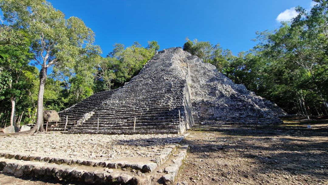
The monumental center, occupying an area of 2 square kilometers, consists of five architectural groups: Koba, Nohch-Mul, Makanshok, Chumul-Mul, and Group D (“Painted Group”). Apparently, in Koba we encounter a fairly common phenomenon in large Maya cities known as the “wandering center.” In brief, the essence of this phenomenon lies in the sequential elevation and transformation of a particular complex into the city’s core, after which, some time later, with the rise of the next group, activity in the previous one is minimized. Thus, in the 5th–6th centuries, the center of social, religious, and political life was the Koba complex, located between the Koba and Makanshok lakes. Then, in the 7th century, it was replaced by the Makanshok group, located 1 km southeast of Koba on the right bank of Lake Makanshok: besides extensive construction in this group, all monuments between 613 and 682 AD were erected here. In the 8th century, the ritual-administrative core moved to Nohch-Mul. As for Postclassic activity, it is primarily associated with the Chumul-Mul complex and the “Painted Group.” The outskirts of the city’s central part cover an area of 8 km² and are represented by architectural groups much smaller than those mentioned above. Here, there is an extremely high concentration of large elite residential groups, among which the complexes of Tsib-Mul, El-Quartel, and others stand out, having close connections both with the architectural complexes of the urban epicenter and with the network of intra-city roads.
The peripheral zone, occupying about 2 square kilometers, consists of secondary ceremonial-administrative complexes located outside the city perimeter: Kubulte, San Pedro, Shmakaba, Telkosh, Chan-Mul, Mulukbaoob, Nuk-Mul, Kukikan, Kitamna. Besides including temple and administrative buildings intended to serve as relays of political and cult activity emanating from the center, these complexes, as far as can be judged, were also residences of royal officials, representatives of the highest palace elite circles who carried out this activity locally. The additional zone — the largest in area — consists of an inner contour (15 square kilometers) adjacent to the urban epicenter and an outer contour, which in fact is the Koba district (43 square kilometers). Here is concentrated most of the known residential groups to date, comprising about 6,000 buildings inhabited by members of the elite, middle class, and ordinary community members. Supplemented by material obtained through GIS analysis, it was established that the residential structure of ancient Koba represented a so-called “general concentric pattern.” The essence of this model lies in the existence of several qualitatively distinct urban zones encircling the city center. Each of these zones generally does not overlap or mix with another, having quite clear boundaries. In Koba, this model is expressed, as noted above, in the following sequence: the central part of the city with public, palace, and temple complexes — elite districts with the highest concentration of groups of the highest status and a small number of residential complexes of ordinary community members, probably serving their more noble neighbors — extensive areas with a minimal number of buildings belonging to the elite and middle class but abundant in houses of ordinary community members — a ring of residences of the most noble officials marking the approximate boundary of the urban district.
The architectural style of Classic period Koba does not demonstrate characteristic elements of northern Maya lowlands architecture, such as columns that lightened building walls, mascarons decorating temple structures in Yucatan, and others. At the same time, there is a significant similarity with the Peten style — for example, buildings in Koba were constructed from unworked stone slabs, which were subsequently covered with plaster smoothing out textural irregularities and then painted in one or several colors. In the Postclassic period, the Costa Oriental style predominates in Koba, widespread along the Caribbean coast of Quintana Roo. The main types of Koba’s buildings are entirely typical for Classic Maya cities: the monumental center abounds with temples, palace ensembles, and plazas. The Koba group, covering 8 hectares, consists of three parts: in the west is a huge plaza, to which a ballgame court adjoins at the northeast corner; the central and eastern parts form a labyrinth of numerous residential, administrative, and temple buildings surrounding courtyards-patios located at different heights and connected by a complex system of stairs and passages; the group has a clear west-east orientation.
Sources:
Thompson J.E.S. A Preliminary Study of the Ruins of Cobá, Quintana Roo, Mexico. Washington, 1932
Savchenko Ivan Antonovich: Koba: On the Question of the Settlement Structure of a Classic Maya City
Antonia Benavides C. Cobá, una ciudad prehispanica de Quintana Roo: guia oficial. Mexico, 1981
