54490, Hostikantie 28, 54490 Lappeenranta, Finland

In the autumn of 1940, after the end of the Winter War, to replace the lost Mannerheim Line, the Commander-in-Chief of the Armed Forces Mannerheim appointed Lieutenant General Edvard Hanell as the chief of the defensive line construction. Under his leadership, a plan was approved to build a defense line along Finland's eastern border. It was named the Salpa Line (salpa in Finnish means bolt or latch). The construction mainly took place during the 1940-1941 armistice period.
The Salpa Line is the largest construction project of independent Finland. In total, 728 concrete structures and 3,000 wooden field fortifications were built. The fortifications span over more than 30 municipalities. In the spring of 1941, when construction was at its peak, about 35,000 civilian builders and 2,000 members of the women's Schutzkorps organization participated. With the start of World War II, or the "Continuation War," as termed in Finnish, in the summer of 1941, work was halted, armaments were removed and sent to the front. Construction resumed only at the beginning of 1944 and continued until the end of the war with the USSR on September 4, 1944. The fortifications did not participate in combat, but their existence was an important factor in the Soviet-Finnish negotiations of 1944.

The line stretched from the Gulf of Finland to the Arctic Ocean — its length is almost 1,200 km. It is the largest fortification structure in Scandinavia. It included 728 concrete structures, 3,000 wooden-earth fortifications, 225 km of wooden stakes, 130 km of anti-tank ditches, and 350 km of trenches (including concrete ones).
A chain of fortification barriers was erected along the entire border from the Gulf of Finland to the Arctic Ocean. The fortifications formed a continuous defensive chain between the Gulf of Finland and Lake Saimaa. The straits between Lakes Saimaa and Pielinen were fortified. Fortifications were built along the entire border from Virolahti to Savukoski, though their density was uneven: 90% of all barriers were constructed on the section between the Gulf of Finland and Lake Saimaa. No combat took place along the line, which explains the relatively good preservation of the defensive structures.
On this section, in terms of "strength," the Salpa Line surpassed the Mannerheim Line. The depth of the line was 15-20 km — the distance between the front line of Virolahti, Miehikkälä, Ylämaa, Lappeenranta and the rear positions of Hamina, Luumäki, and Lemi.
The DOT (pillbox) constructions represented an evolution of the proven "million" DOTs of the Mannerheim Line. These were machine gun, artillery, and artillery-machine gun semi-caponier flanking fire structures combined with barracks for 20 people. The thickness of the ceiling slabs and walls was increased to 2.5 meters, and natural caves were often used as shelters.
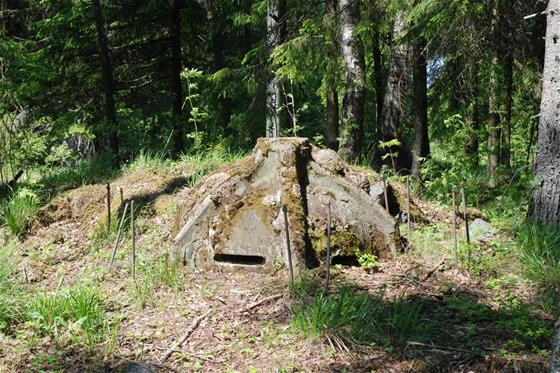
In 1942, a technology purchased from the USA for constructing spherical concrete shelters was mastered. The main advantage was the rapid construction of such structures — 5-6 people could build one in 4-5 hours, plus curing in the open air for 12-16 hours.
First, a pit was dug with a diameter matching the outer wall. In the pit, a special rubber balloon was inflated, serving as the inner formwork. Then an outer steel formwork was installed, and concrete was poured into the cavity. After pouring, the concrete was vacuumed for 1-2 hours, and the formwork was removed. The wall thickness was 61 centimeters, and the internal diameter was 3 meters. Due to vacuuming, the concrete had greater strength properties than with ordinary technology. After curing in the open air, such a structure could withstand a hit from a 75-mm shell. Inside such a bunker, 10 people with weapons could be accommodated. A stove was provided for heating.
Concrete or rock-cut trenches were widely constructed. Granite stakes (as on the Mannerheim Line) were used as anti-tank obstacles.
The line did not participate in military actions, so its fortifications remain in their original condition. In the southern part of the line, near the highway to Helsinki (E18), there are two museums: the Bunker Museum in Virolahti and the Salpa Line Museum in Miehikkälä. There is also the Salpa Trail route.
The museums consist of a pavilion and an open-air area. The latter is a forest park with paths and routes. All structures along the routes have been restored and equipped as they were at the end of the war in 1944.

At the museum sites, you can see:
- reinforced concrete DOTs with armaments;
- spherical concrete bunkers, formwork, and equipment for their construction;
- trenches and communication passages, including those cut into rock;
- anti-tank ditches;
- lines of anti-tank barriers;
- stones installed by builders with images of a lion (the state symbol of Finland);
- artillery installations, a T-34 tank (Finnish name – "Sotka").
For lovers of outdoor activities, hiking, and tourism, a special route — the Salpa Trail — has been developed, 50 km long. Hiking the trail allows you to get acquainted in detail with the Salpa Line fortifications as well as the beautiful nature of southern Finland.
The trail begins at Cape Mayaniemi in Virolahti with sea views, passes through the Bunker Museum in Virolahti, and then to the Salpa Line Museum. The final point of the hike is the Hostikka cave in South Karelia. Along the way, you will see Salpa Line structures: various reinforced concrete buildings, rock shelters and caves, and other defensive structures. All are equipped with signs and accompanying informational plaques at the points of interest.
The route is equipped with detailed blue arrow signs and information boards. Every kilometer of the trail has from 2 to 5 signs with the trail name (Salpapolku) and posts with its emblem, depicting an otter with a backpack. There are also rest areas, campsites, and toilets.
Traveling along the shore of Lake Saimaa, on the Lappeenranta - Taavetti (Luumäki) road, you can see the structures of the Luumäki sector of the Salpa Line.
The structures are located on both sides of the road — north to the lake, south to the railway, about 500 meters. They are easy to find by following the worn paths.
The DOT closest to the road is an artillery-gun semi-caponier for flanking fire. The gun is intended for fighting tanks. The bunker entrance is guarded by a turret installed from a Soviet BT tank. Inside the bunker, its simple furnishings, hermetic doors, and the observation cupola are well preserved and accessible.
Opposite, across the road, wandering along the paths, you can find several more concrete structures, restored trenches, and bunkers.
Source:
http://www.peterburg.biz/liniya-salpa-finlyandiya-istoriya-opisanie.html#ixzz8SBYjvcjg
https://ru.wikipedia.org/wiki/Линия_Салпа
