Pivan Tunnel (Amur Tunnel).

G368+W4 Central District, Komsomolsk-on-Amur, Khabarovsk Krai, Russia

An unfinished and abandoned railway tunnel on the right bank of the Amur River, near Komsomolsk-on-Amur. It is located north of the village of Pivan, in the area of the Pivan gardening association, passing under the ridge of Pivan Hill. The tunnel has no official name, so it is usually referred to by the locality — the Pivan Tunnel (sometimes the alternative name "Amur Tunnel" is also used). It is one of the first tunnels of the Baikal-Amur Mainline (BAM).
In the 1930s, according to the state plan for the development of natural resources in the Far East regions, the construction of several new industrial centers and railway lines was undertaken. In 1936, the construction of the first railway line Volochaevka-2 — Komsomolsk-on-Amur was completed, and in 1937 the laying of the Komsomolsk — Sovetskaya Gavan line began, which was to include a bridge crossing over the Amur River.
The first surveys for the BAM bridge crossing over the Amur River were conducted in the second half of 1932 by a team from the Lengiprotransmost Institute, which outlined three possible bridge locations within the city: one upstream, another downstream, and a third within Komsomolsk city limits.

In 1936, a resolution by the bureau of the Dalkraykom of the VKP(b) addressed the development of the railway hub in Komsomolsk. The following were to be constructed:
A railway town for 250,000 people (project author Rakov),
A railway branch from Komsomolsk-on-Amur station to the Amur River pier,
A bridge over the Amur (project author Tsybaev),
A tunnel on the right bank of the Amur (technical project by the Lengiprotransmost Institute).
In 1939, in the Komsomolsk-on-Amur area, the Tumnin expedition led by Tatartintsev conducted final surveys for the construction of a bridge over the Amur River. The first two options were discarded because they involved building a long viaduct over the left-bank floodplain. The third option, although requiring a long bridge (2.5 kilometers) and a tunnel on the right bank (800 meters), was recognized as the most economical and technically simple. In 1940, tunnel excavation began. However, the Great Patriotic War altered plans: the bridge was never started, and in 1942 tunnel construction was halted.
The tunnel crossing surveys through Pivanskaya Sopka were carried out by a comprehensive team led by engineer Kuznetsov. Chief geologist Kisel. Project author Vainshtein. According to the report of the Lower Amur ITL, a tunnel works office was established for tunnel construction, courses were opened to train tunnel specialists for the Baikal-Amur Mainline, and a special tunnel laboratory was created.
All crews were staffed with highly qualified specialists — prisoners: locksmiths, machinists, electric welders. The courses trained tunnel foremen, foremen’s assistants, and surveyors. Those engaged in tunnel construction were entitled to enhanced rations, full sets of bedding, and double sets of uniforms.
From February 1940, 250 people from the bridge separate camp point (OLP) of the Lower Amur camp worked on the bridge crossing construction.

The construction included a quarry behind Pivanskaya Sopka, which prisoners called "Pionersky." Next to the quarry was a stone crusher under which wagons rolled on rails. They positioned themselves under a bunker for loading crushed stone rubble. The rubble was transported into the tunnel and used to cover the "floor," on which the railway track was to be laid later.
On October 26, 1940, an 800-meter-long adit was driven through.

At the end of 1940, construction was suspended.
At the beginning of 1941, tunnel construction, as well as the railway bridge over the Amur, began to be wound down because the rails were needed by the Bureinsky camp for the construction of the Izvestkovy — Urgal railway line. Human and transport resources were redirected to the Komsomolsk-Urgal line.
In 1942, an order was issued "On the completion of work on the conservation of the tunnel."
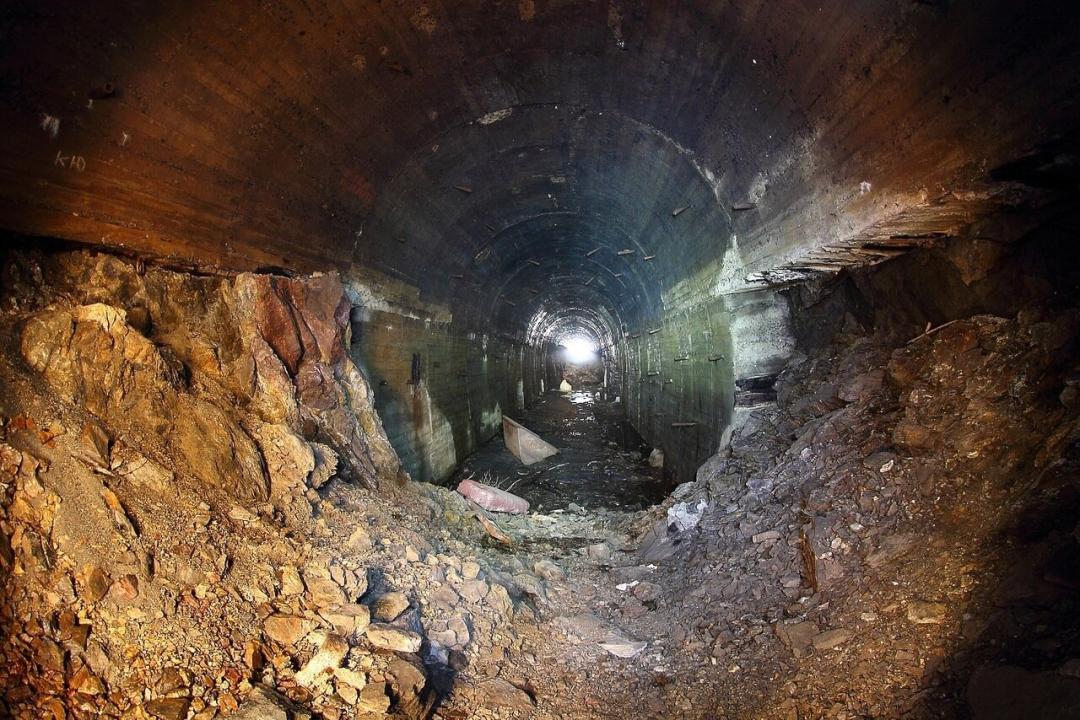
The tunnel was constructed from both sides. Excavation was carried out by drilling and blasting. From the eastern portal side, the face was developed to the full tunnel cross-section. From the western portal side, excavation was done in two benches.
The tunnel profile is single-pitched, rising from the eastern to the western portal with slopes ranging from 0.5 to 1.7%. The lining shape is a steep arch. There is no lighting in the tunnel; ventilation is natural.
1943 was a turning point in the Great Patriotic War. At the same time, Japan, an ally of Nazi Germany, was preparing to invade the Soviet Far East. It was then that the State Defense Committee decided: "Build a railway from Komsomolsk-on-Amur to Sovetskaya Gavan." The deadline for opening operational traffic, primarily from Komsomolsk to Vanino Bay, was set for August 1, 1945. It was proposed to revise the previously developed construction project, originally planned for 4 years, simplifying it to a 2-year construction period.
Instead of a 2.5-kilometer bridge over the Amur River, build a ferry crossing with two ferries.
When crossing the Sikhote-Alin mountain range, instead of two tunnels, build a road bypassing the mountain massif using triple locomotive traction (laying more than 500 km of railway tracks).
The road construction was assigned to the People's Commissariat of Internal Affairs represented by the then head of the Railway Project of the GULZHD NKVD, F. A. Gvozdevsky. The project was designated "Construction No. 500." All expedition leaders, comprehensive teams, and construction trusts were given the construction chief's order, Major General Gvozdevsky: "Do not build bridges or tunnels!"
In 1965, the question arose about resuming the construction of the bridge crossing over the Amur. It was necessary to consider new options taking into account the increased clearance height, increased suspended load, and, most importantly, designing supports for combined automobile and railway traffic. First, it was decided to assess the suitability of the 1939 option, approved based on the 1932 survey materials.
Increasing the height was impossible due to the low location of the Pivan station. If a new station were built on the right bank at higher elevations, the height of the approach embankment within the city would also need to be increased. Moreover, this would mean abandoning the already started construction of the Pivan tunnel.
Reasons for rejecting the construction of a drawbridge span:
  • It is cumbersome.
  • It would create certain obstacles to navigation on the Amur.
It is difficult to determine the location of this span: the river's hydrological conditions are unfavorable; the Amur's channel at the bridge crossing site has an excessive live cross-section, causing constant reshaping with significant lateral shifts of the fairway and changes in depth. Additionally, the island located upstream of the proposed bridge was moving downstream and growing upward, which could adversely affect the redistribution of water flow across the river section and cause dangerous scouring. Besides this, the narrowed part of the river below the bridge and several small islands predetermined the formation of large ice jams and scours in this area, affecting the stability of the supports.
The conditions for entering the bridge forced designers to place the automobile part of the crossing on the upstream side of the supports. In this case, during the initial period of bridge operation, when only railway loads would act on it, the lower part of the supports, without automobile span structures, would be in very unfavorable conditions. To ensure sufficient loading, it was necessary to increase the foundation sizes of the supports. Additionally, to exit the automobile road from the bridge, a new large-section and long tunnel had to be built.
All these conditions determined the fate of the Pivan tunnel. After long surveys, it was decided to build the bridge crossing over the Amur in another location.
The Pivan tunnel is completely abandoned. Construction and design documentation for the structure have not been preserved. There is no acceptance certificate for the tunnel. The tunnel has the following characteristics:
non-standard dimensions (caused by over-excavation and under-excavation of soil during drilling and blasting);
  • defects in the roadway combined with significant moisture (due to leaks through technological joints in the monolithic reinforced concrete and shotcrete lining — there is no waterproofing behind the tunnel lining, as well as due to unorganized drainage);
  • complete absence of tunnel lighting;
  • lack of protection against rockfall at the approaches to the Western and Eastern portals;
  • absence of deformation and seismic joints in the tunnel;

In the 2000s, local entrepreneurs wanted to set up mushroom-growing workshops in the tunnel adit. The tunnel has become a pilgrimage site for urban explorers (diggers).
The eastern portal is located on the territory of the "Pivan" gardening association. The road leading to the tunnel within the "Pivan" gardening area is called Tunnel Street. Thanks to lease agreements between the "Pivan" gardening association and the Pivan village administration, the eastern portal of the tunnel (excavation bottom and slopes) began turning into an unmanaged dump. Therefore, in December 2011, an initiative group "Tunnel" was formed at the Komsomolsk-on-Amur branch of the Russian Memorial Society, aiming to restore the historical complex on the right bank of the Amur near Pivan. In 2012, through the joint efforts of enthusiasts, gradual clearing of the tunnel excavation began, the garbage on the slopes was covered with sand by the district administration, and the area around the eastern portal was fenced with barbed wire.
The tunnel was forgotten; a gardening community formed around it, the tunnel entrance turned into a dump, and only the street name "Tunnel Street" in the gardens reminds of the past.
In early 2012, on the hill directly above the tunnel entrance from the Amur side, a memorial sign to the victims of political repression was installed (author and executor — Komsomolsk resident Viktor Zagryanin).

Sources:
https://cvarnou.livejournal.com/43455.html
https://ru.wikipedia.org/wiki/Пиванский_тоннель
http://kfss.ru/content/pivanskiy-tonnel

Follow us on social media

More stories from Russia: Industrial Heritage

Icebreaker "Lenin" - the world's first surface ship with a nuclear power plant

Fontanka River Embankment, 203, Saint Petersburg, Russia, 190121

**"Lenin"** — an atomic icebreaker, the world's first surface vessel with a nuclear power plant. The icebreaker was built in the USSR, primarily to service the Northern Sea Route. The atomic ship project was developed at TsKB-15 in 1953–1955 following the decision to build a nuclear icebreaker made on November 20, 1953, by the Council of Ministers of the USSR.

Icebreaker "Lenin" - the final berth

floating berth a/l "Lenin", Portovy proezd, 25, Murmansk, Murmansk region, Russia, 183038

On May 5, 2009, the nuclear icebreaker "Lenin" (https://reveal.world/story/ledokol-lenin-pervoe-v-mire-nadvodnoe-sudno-s-yadernoj-silovoj-ustanovkoj) docked in the center of the city of Murmansk at the marine terminal, quickly becoming the "calling card" of the Murmansk region and one of the most visited tourist attractions of the Kola North.

Pier "Stakan" — the place of sea trials for the icebreaker "Lenin"

CH3H+84 St Rucheek, Leningrad Oblast, Russia

In the north of Primorsk, there is a settlement called Manola. In Manola, in the late 1950s, the first atomic icebreaker in the world, "Lenin," was tested. For the tests, a special pier was built; this unique structure is located on the territory of the modern "Admiralty Shipyards" recreation base. It was named "The Glass" because it resembles one.

Peter the Great's Dock

Makarovskaya St., 71, Saint Petersburg, Russia, 197762

“…This building, which not only can compete in excellence with the best ancient works, but also far surpasses them in suitability and usefulness, and is now unique in the whole world” *Saint Petersburg Gazette*, October 13, 1752

Dock basin of the Peter the Great dock

Yakor'naya Square, 3, Saint Petersburg, Russia, 197762

The dock basin was built near the Maritime St. Nicholas Cathedral, next to the Summer Garden, according to the project by engineer Lyuberas. Its construction lasted from 1734 to 1752. The average water level in the basin was 11.4 meters.

Water Tower of the Main Water Supply Station

Shpalernaya St., 56, Saint Petersburg, Russia, 191015

The old red brick tower rising above the street had faithfully served the city until recently as the water tower of the Main Water Supply Station.

Engineer Inka Tower or Verevskaya Tower

Zaozernoe SNT, 242, Zaozernoe SNT, Leningrad Region, Russia, 196632

This is a rather unusual landmark of Saint Petersburg. It is a ruined water tower from the early 20th century, but the atmosphere of desolation gives it a special charm. The Inka Tower was severely damaged during the Great Patriotic War, but unlike other water supply structures, it was never restored. It stands in a field and serves as a reminder of former glory.

The Singing Tower in Tsarskoye Selo

Lyceyskiy Lane, 7, Saint Petersburg, Russia, 196601

In the depths of the oldest quarter of Tsarskoye Selo stands the 30-meter-high Singing Tower. This is a unique 19th-century engineering structure designed simultaneously to house a water tower and pumping station, as well as an electrical station serving the palace buildings and the city. The beginning of the city's electric lighting dates back to the same year, 1887, when the tower was connected to the city water supply. The steam drives of the pumps, which pumped water into the tower's reservoirs, simultaneously powered the electric generators.

Water tower at "Red Nail Maker"

6 building 1, letter B, 25th line of Vasilievsky Island, Saint Petersburg, Russia, 199106

The water tower at the "Red Nail Factory," designed by Yakov Chernikhov in 1930-1931, would later be included in all global reference books and architecture textbooks as a unique example of avant-garde constructivism. The architect's innovation lay not only in the striking design of the tower and the unusual arrangement of spatial-visual accents—where the rounded projection of the water tank rests on two slender columns, creating the illusion of a transparent nail shaft, always painted in the colors of the sky—but also in bold experiments with the shaping properties of reinforced concrete—the primary building material of the first Soviet five-year plans and the global industrial revolution of the first half of the 20th century.

Institute of Robotics Tower - Sauron's Castle

Svetlanovsky Ave., 12, Saint Petersburg, Russia, 195427

The most legendary tower of Saint Petersburg is located at the corner of Svetlanovsky and Tikhoretsky Avenues. It is the complex of the Central Research Institute of Robotics and Technical Cybernetics (TsNII RTK).

Sea (Oranienbaum) Canal

WQ84+VJ Petrodvortsovy District, Saint Petersburg, Russia

A canal in the city of Lomonosov, Petrodvortsovy District of Saint Petersburg. It begins at Dvortsovy Prospekt and flows into the Neva Bay of the Gulf of Finland.

Imperial (Tsar's) Pavilion of the Imperial Branch

Akademicheskiy Ave, 31, Saint Petersburg, Russia, 196605

The Imperial (Tsar's) Pavilion is an unused building of the railway station at the junction of the Petersburg-Warsaw Railway branches and the Imperial branch. The pavilion is located in the city of Pushkin. To accommodate trains passing through the Aleksandrovskaya station of the Petersburg-Warsaw Railway, heading to Tsarskoye Selo, construction of the Tsar's Pavilion began in 1895.

Baltic Fleet Machine School

Petrovskaya St., 9, Saint Petersburg, Russia, 197762

Anyone who has ever walked along Petrovskaya Street in Kronstadt has seen the building with a huge stained-glass window in the Art Nouveau style. This is the former machine school of the Baltic Fleet; it housed the stokers' school, and inside the building there was a working model of a military ship's stoker room, a machine school, and a marine technical college.

Hemp Bridge

Petrovskaya St., 6b, Saint Petersburg, Russia, 197762

The Penkovy Bridge was built in 1873 and rebuilt in 1887-1888. Drawbridges over the Obvodny Canal, which the Penkovy Bridge originally was, allowed the passage of sailing ships with tall masts along the canal. It spans the Obvodny Canal. The crossing acquired its modern appearance in 1971–1972, during another reconstruction. The bridge has preserved the historic roadway surface, made of cast iron tiles.

Palace Power Station

WQ63+82 Petrodvortsovy District, Saint Petersburg, Russia

In our age, when industrial sites are transformed into exhibition halls, and monuments of industrial architecture hold no less interest for the inquisitive traveler than royal residences and museums, the Oranienbaum palace power station complex could have found a second life. But, alas, at present it is in a rather deplorable condition.

Palace Power Station in Pushkin

Malaya St., 7-9, Saint Petersburg, Russia, 196601

The history of electric lighting in Tsarskoye Selo began in 1887; the first power station in Russia was housed in the Singing Tower and provided light to 3,000 lamps. By 1896, its capacity was no longer sufficient, and it was decided to build another power station. By 1896, Tsarskoye Selo had become the first European city with fully electric street lighting.

Water pumping station – Shtakenshneider water-lifting machine

VRXW+M6 Petrodvortsovy District, Saint Petersburg, Russia

Near the shore of the bay, between the palace meadow and the mouth of the Kristatelka River, in its steep bend, there is a picturesque clearing where, among apple trees, stands a red brick ruin with a long chimney protruding upwards. This is all that remains of the palace water pumping station after the destruction of the Great Patriotic War. Although the Sergievka park was outside the occupied territory, within the Oranienbaum bridgehead, the ensemble was heavily damaged by shells.

Mysterious Tower in Villozy

11V, Villozy, Leningrad Region, Russia, 188508

The old buildings in Villosi, created at the beginning of the 20th century, are a water pumping station, the predecessor of the current Dudergof station of the "Vodokanal" on the lake shore. It was intended to supply water from the Orlovskie springs to military camps and Krasnoye Selo.

Ekranoplan "Lun" - Caspian Monster

W9RH+8F Arablar, Republic of Dagestan, Russia

One of the projects of new and promising weaponry created in the 1980s was the ekranoplan "Lun." Abroad, these aircraft were admired for their interesting appearance and feared for their capabilities. Due to changes in the country, there was an attempt to convert the ekranoplan "Lun" from a ship destroyer into a rescue vehicle, but later it was completely abandoned and left to fate at one of the factories.

Caspian Fort Boyard - Workshop 8 of the Dagdiesel Plant

VP85+RM Turali 4th, Republic of Dagestan, Russia

The most incredible building of the Soviet avant-garde is located in the Caspian Sea, 2.7 kilometers from the shore. This artificial island has become a kind of calling card for the Russian part of the Caspian Sea. Initially shrouded in secrecy, it now patiently awaits the decision of its fate.

Radio testing range owned by FSUE Research Institute "Vector".

CF6H+82 Peski, Leningrad Oblast, Russia

Former radio testing site of FSUE Research Institute "Vector." Two spheres with diameters of 15-18 meters have been preserved.

Reinforced Concrete Canopy of the "Iron-Concrete" Partnership

Bolshaya Alley, 24, Saint Petersburg, Russia, 197183

On the northern shore of Kamenniy Island stands a reinforced concrete canopy. Although it looks quite weathered by time, it still attracts attention with the elegance of its forms. This is one of the artifacts left from the International Construction and Art Exhibition of 1908, which played an important role in the history of Russian architecture.

Tunnel under the Amur River

20 Sanatornaya St., Khabarovsk, Khabarovsk Krai, Russia, 680054

Now in Khabarovsk, everyone knows about the tunnel under the Amur River. But 40-50 years ago, few people knew about it: the tunnel was built secretly. This unique military-civilian facility, remarkable for its characteristics, was constructed in the late 1930s and still remains the only operational underwater railway tunnel in Russia.

Sakhalin Tunnel

The text "9R436G3J+PW" appears to be a code or identifier and does not require translation. If you intended to provide an image or text in another language for translation, please share it.

Unfinished construction of the tunnel crossing through the Tatar Strait, one of the construction projects of the GULAG of the USSR Ministry of Internal Affairs and the USSR Ministry of Railways.

Vitebsky Railway Station

Zagorodny Prospekt, 52, Saint Petersburg, Russia, 190013

The oldest railway terminal in Saint Petersburg and the first railway station in Russia. The railway connecting Tsarskoye Selo and Saint Petersburg in 1837 became the first public railway in the country.

406 mm B-37 Gun - The Most Powerful Weapon of the USSR

Ryabovskoe Highway, 130, Saint Petersburg, Leningrad Region, Russia, 195043

The 406 mm naval gun B-37 is a Soviet shipborne weapon with a caliber of 406.4 mm (16 inches). B-37 type guns, mounted in triple turret installations designated MK-1 (Naval Ship № 1), were intended to arm the Soviet Union-class battleships, and in the late 1940s–1950s (in modernized MK-1M turret installations) the Project 24 battleships. Due to the cessation of construction of the Soviet Union-class battleships in July 1941, work on the creation of the B-37 gun and the MK-1 turret for it was halted. An experimental B-37 gun installed at the Rzhev firing range from 1941 to 1944 participated in the defense of Leningrad against German forces and, as part of Battery No. 1 of the Scientific Research Naval Artillery Range, supported the troops of the Leningrad and Volkhov Fronts in various directions. During the combat operations, the B-37 gun fired 81 rounds at enemy forces.

Rzhev Artillery Range

XGVG+5H Vsevolozhsk, Leningrad Oblast, Russia

Founded in 1854 as the Main Artillery Range of the Russian Imperial Army, it was initially located at Volkovo Field (now Volkovo Cemetery) as part of a single "experimental" battery. In 1863, the current territory of the range — the right part of Okhta Field, stretching about 16 kilometers to the Toksovo Heights — was allocated to the naval department. The range began operating in 1879 and was the most famous artillery range both in the Russian Empire and in the USSR.

Porokhovskoye Cemetery, Saint Petersburg

Ryabovskoe Highway, 78, Saint Petersburg, Russia, 195043

In July 1715, by the decree of Peter I, a gunpowder factory was established on the banks of the Okhta and Luppa rivers, which gave its name to the cemetery opened at the Church of Elijah the Prophet, consecrated in 1722. The Porokhovskoye Cemetery is not among the most famous and prestigious, but it has a long history and is quite picturesque. It is located on the northeastern outskirts of Saint Petersburg, in an area with a hilly terrain unusual for our flat city. It is squeezed between Krasina Street and Ryabovsky Highway, with its southern boundary marked by the winding Lubbya (Luppa) River, a left tributary of the Okhta. The cemetery covers an area of about 9 hectares.

Okhtinskaya Fire Station

Building 21, block A, room 1N, office 3, Bolshoy Okhtinsky Ave., Saint Petersburg, Russia, 195027

Okhta Fire Station is one of the few fire stations in St. Petersburg from the 19th century that have survived to this day. Its watchtower is a recognizable symbol of Greater Okhta. The Okhta firefighters moved into this building in 1886 or 1887.

Okhta Gunpowder Plant

sh. Revolyutsii, 130, Saint Petersburg, Russia, 195030

The origin of the gunpowder factory dates back to 1715. To supply the Russian army in the war against Sweden for access to the Baltic Sea, by decree of Peter the Great, a gunpowder factory called the "Gunpowder Mill" was built on the Okhta River at the confluence with the Luppa River.

BUS Vertical (Large Universal Stand)

W24P+W7 Sosnovy Bor, Leningrad Oblast, Russia

BUS Vertical (Large Universal Stand) belongs to the State Optical Institute. Vertical is a large unfinished and abandoned complex.